
Magnitude |
3.5 |
| Date & Time (UTC) | 2013-10-21 12:20:24.3 |
| Date & Time (Local) | 1392/7/29 15:50:24.3 |
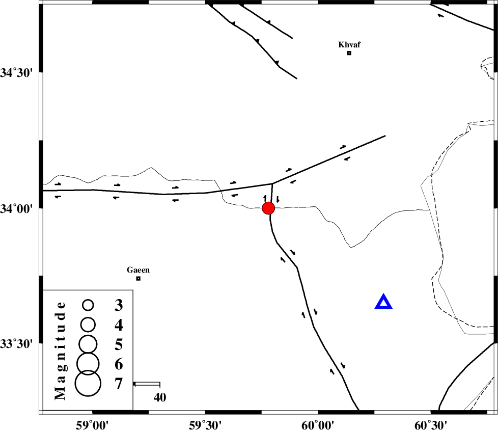
| Location | Lat:34 Lon: 59.78 |
| Region | 61 km North-East of Qaen |
Nearest Cities |
|
| 32 km South of Ebrahimi, Khorasan(center) Province | |
| 36 km South West of Pasgah-e chazul, Khorasan(center) Province | |
| 38 km North West of Abiz, Khorasan(south) Province | |
| 40 km South of Zuzan, Khorasan(center) Province | |
| 41 km South West of Biasabad, Khorasan(center) Province | |
| Depth | 18 km |
| Agency | |
Faults within 150 km: |
|
| ABRIZ_F (Length: 114 km) , Distance to epicenter: 5 km | |
| DASHT_E_BAYAZ_F (Length: 177 km) , Distance to epicenter: 10 km | |
| JANGAL_F (Length: 111 km) , Distance to epicenter: 54 km | |
| Number of Phases | 4 |
| RMS | 0.1 |
| Number of Stations | 3 |
| Error in Latitude | >5.9 km |
| Error in Longitude | 2.1 km |
| Error in Depth | 3.2 km |
Download waveform in seisan format
to download seisan software Click here
to access information about IIEES stations Click here
Amplitude | ||||||||
| UID | Agency | Station | Component | Amplitude | Period | Arrival Time | Proccessing Time | Signal Clip |
| 90834 | IIEES | SHRT | N | 5223.1 | 0.16 | 2013-10-21 12:20:44 | 2013-10-21 01:43:00 | n |
| 90835 | IIEES | SHRT | E | 6606.8 | 0.12 | 2013-10-21 12:20:44 | 2013-10-21 01:43:00 | n |
| 90836 | IIEES | TABS | N | 97.4 | 0.4 | 2013-10-21 12:21:39 | 2013-10-21 01:43:00 | n |
Phase | ||||||||||||
| Agency | Station | Component | Phase Type | Phase Quality | First Motion | Observed Arrival Time | Time Residual | Loc. Flag | Input Weight | Distance | Azimuth | |
| IIEES | SHRT | Z | Pg | E | 2013-10-21 12:20:35 | 0.05 | y | 61 | 129 | |||
| IIEES | BSRN | Z | Pn | E | 2013-10-21 12:21:00 | -0.05 | y | 233 | 195 | |||
| IIEES | TABS | Z | Pn | E | 2013-10-21 12:21:02 | -0.05 | y | 250 | 262 | |||
| IIEES | TABS | N | Sg | E | 2013-10-21 12:21:34 | 0.05 | y | 250 | 262 | |||