
Magnitude |
4 |
| Date & Time (UTC) | 2013-10-28 10:32:34.3 |
| Date & Time (Local) | 1392/8/6 14:02:34.3 |
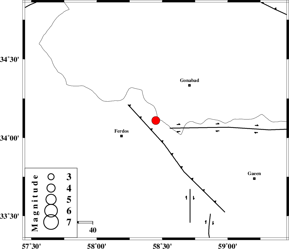
| Location | Lat:34.11 Lon: 58.45 |
| Region | Khorasan(center) Province, 26 km East of Ferdows |
Nearest Cities |
|
| 11 km North of Masbaei, Khorasan(center) Province | |
| 15 km North East of Baghestan-e olia, Khorasan(center) Province | |
| 18 km West of Kakhak, Khorasan(center) Province | |
| 21 km East of Brun, Khorasan(center) Province | |
| 22 km West of Marghash, Khorasan(center) Province | |
| Depth | 18 km |
| Agency | |
Faults within 150 km: |
|
| DASHT_E_BAYAZ_F (Length: 177 km) , Distance to epicenter: 11 km | |
| FERDOWS_F (Length: 101 km) , Distance to epicenter: 18 km | |
| DUSTABAD_F (Length: 22 km) , Distance to epicenter: 54 km | |
| Number of Phases | 7 |
| RMS | 0.4 |
| Number of Stations | 5 |
| Error in Latitude | >5.4 km |
| Error in Longitude | 4.1 km |
| Error in Depth | 9.3 km |
Download waveform in seisan format
to download seisan software Click here
to access information about IIEES stations Click here
Amplitude | ||||||||
| UID | Agency | Station | Component | Amplitude | Period | Arrival Time | Proccessing Time | Signal Clip |
| 90874 | IIEES | GHVR | E | 46.2 | 0.51 | 2013-10-28 10:36:14 | 2013-10-28 10:54:00 | n |
Phase | ||||||||||||
| Agency | Station | Component | Phase Type | Phase Quality | First Motion | Observed Arrival Time | Time Residual | Loc. Flag | Input Weight | Distance | Azimuth | |
| IIEES | TABS | Z | Pg | E | 2013-10-28 10:32:56 | 0.17 | y | 133 | 248 | |||
| IIEES | SHRT | Z | Pg | E | 2013-10-28 10:33:02 | -0.77 | y | 178 | 106 | |||
| IIEES | SHRT | N | Sg | E | 2013-10-28 10:33:25 | 0.58 | y | 178 | 106 | |||
| IIEES | BSRN | Z | Pn | E | 2013-10-28 10:33:12 | 0.07 | y | 246 | 165 | |||
| IIEES | BSRN | E | Sg | E | 2013-10-28 10:33:43 | 0.01 | y | 246 | 165 | |||
| IIEES | KRBR | Z | Pn | E | 2013-10-28 10:33:41 | -0.37 | y | 484 | 200 | |||
| IIEES | GHVR | Z | Pn | E | 2013-10-28 10:34:04 | 0.4 | y | 664 | 276 | |||