
Magnitude |
2.5 |
| Date & Time (UTC) | 2013-11-06 21:44:47.2 |
| Date & Time (Local) | 1392/8/16 01:14:47.2 |
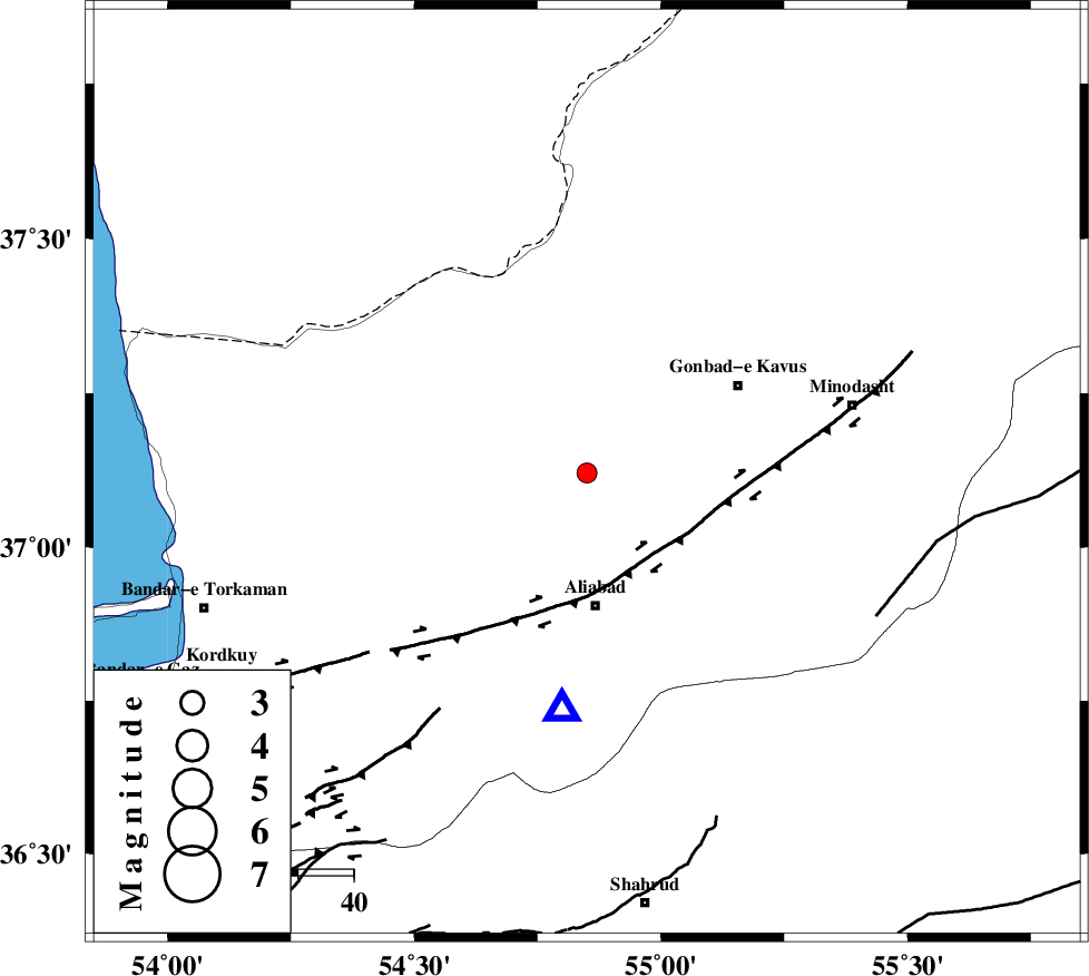
| Location | Lat:37.12 Lon: 54.85 |
| Region | Golestan Province, 23 km North of Ali Abad |
Nearest Cities |
|
| 11 km North East of Gariduji, Golestan Province | |
| 17 km North West of Khanbebin, Golestan Province | |
| 19 km West of Baghli marma, Golestan Province | |
| 21 km North West of Deland, Golestan Province | |
| 24 km North of Ali Abad, Golestan Province | |
| Depth | 17 km |
| Agency | |
Faults within 150 km: |
|
| KHAZAR_F (Length: 523 km) , Distance to epicenter: 16 km | |
| SHAVAR_F (Length: 87 km) , Distance to epicenter: 48 km | |
| ROBATE_QARABIL_F (Length: 168 km) , Distance to epicenter: 58 km | |
| Number of Phases | 6 |
| RMS | 0.1 |
| Number of Stations | 4 |
| Error in Latitude | >5.3 km |
| Error in Longitude | 2.4 km |
| Error in Depth | 3.1 km |
Download waveform in seisan format
to download seisan software Click here
to access information about IIEES stations Click here
Amplitude | ||||||||
| UID | Agency | Station | Component | Amplitude | Period | Arrival Time | Proccessing Time | Signal Clip |
| 90934 | IIEES | BJRD | N | 36.1 | 0.88 | 2013-11-06 21:46:03 | 2013-11-06 10:18:00 | n |
Phase | ||||||||||||
| Agency | Station | Component | Phase Type | Phase Quality | First Motion | Observed Arrival Time | Time Residual | Loc. Flag | Input Weight | Distance | Azimuth | |
| IIEES | BJRD | Z | Pn | E | 2013-11-06 21:45:24 | 0.12 | y | 236 | 73 | |||
| IIEES | BJRD | N | Sg | E | 2013-11-06 21:45:53 | -0.06 | y | 236 | 73 | |||
| IIEES | DAMV | Z | Pn | E | 2013-11-06 21:45:32 | -0.04 | y | 306 | 238 | |||
| IIEES | CHTH | Z | Pn | E | 2013-11-06 21:45:39 | -0.09 | y | 359 | 249 | |||
| IIEES | CHTH | E | Sg | E | 2013-11-06 21:46:28 | 0.06 | y | 359 | 249 | |||
| IIEES | GRMI | Z | Pn | E | 2013-11-06 21:46:14 | -0.02 | y | 639 | 289 | |||