
Magnitude |
2.6 |
| Date & Time (UTC) | 2013-11-13 01:48:36.4 |
| Date & Time (Local) | 1392/8/22 05:18:36.4 |
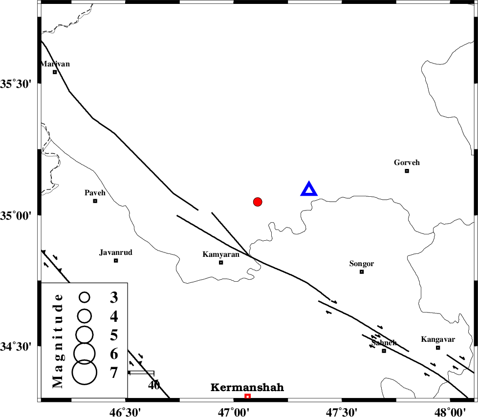
| Location | Lat:35.05 Lon: 47.11 |
| Region | Kurdistan Province, 31 km South-East of Sanandaj |
Nearest Cities |
|
| 7 km of Muchesh, Kurdistan Province | |
| 13 km North East of Yoosefabad, Kurdistan Province | |
| 16 km North East of Void, Kurdistan Province | |
| 16 km North East of Void, Kurdistan Province | |
| 17 km East of Ali Abad, Kurdistan Province | |
| Depth | 14 km |
| Agency | |
Faults within 150 km: |
|
| MORVARID_F (Length: 24 km) , Distance to epicenter: 20 km | |
| SARTAKHT_F (Length: 78 km) , Distance to epicenter: 22 km | |
| PIRANSHAHR_F (Length: 253 km) , Distance to epicenter: 25 km | |
| Number of Phases | 6 |
| RMS | 0.2 |
| Number of Stations | 4 |
| Error in Latitude | >3 km |
| Error in Longitude | 9 km |
| Error in Depth | 7.9 km |
Download waveform in seisan format
to download seisan software Click here
to access information about IIEES stations Click here
Amplitude | ||||||||
| UID | Agency | Station | Component | Amplitude | Period | Arrival Time | Proccessing Time | Signal Clip |
| 90990 | IIEES | ASAO | N | 40 | 0.76 | 2013-11-13 01:50:05 | 2013-11-13 03:25:00 | n |
| 90991 | IIEES | KHMZ | E | 28.1 | 0.52 | 2013-11-13 01:50:07 | 2013-11-13 03:25:00 | n |
| 90992 | IIEES | KHMZ | N | 23.3 | 0.56 | 2013-11-13 01:50:13 | 2013-11-13 03:25:00 | n |
| 90993 | IIEES | GHVR | N | 11.6 | 0.56 | 2013-11-13 01:50:39 | 2013-11-13 03:25:00 | n |
Phase | ||||||||||||
| Agency | Station | Component | Phase Type | Phase Quality | First Motion | Observed Arrival Time | Time Residual | Loc. Flag | Input Weight | Distance | Azimuth | |
| IIEES | ZNJK | Z | Pg | E | 2013-11-13 01:49:13 | -0.29 | y | 229 | 38 | |||
| IIEES | ZNJK | E | Sg | E | 2013-11-13 01:49:41 | 0.12 | y | 229 | 38 | |||
| IIEES | ASAO | Z | Pn | E | 2013-11-13 01:49:18 | 0.29 | y | 272 | 101 | |||
| IIEES | KHMZ | Z | Pn | E | 2013-11-13 01:49:21 | -0.06 | y | 300 | 118 | |||
| IIEES | KHMZ | N | Sg | E | 2013-11-13 01:50:00 | -0.12 | y | 300 | 118 | |||
| IIEES | GHVR | Z | Pn | E | 2013-11-13 01:49:31 | 0.07 | y | 384 | 98 | |||