
Magnitude |
2.9 |
| Date & Time (UTC) | 2013-11-17 14:42:51.5 |
| Date & Time (Local) | 1392/8/26 18:12:51.5 |
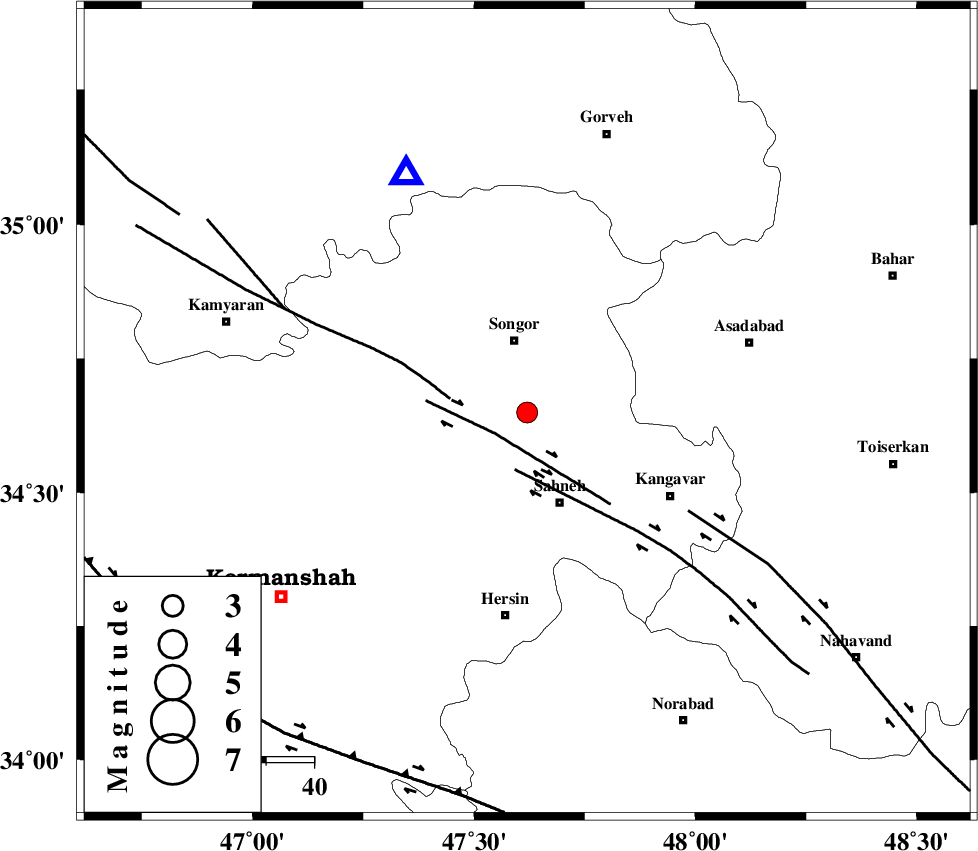
| Location | Lat:34.65 Lon: 47.62 |
| Region | Kermanshah Province, 16 km South of Sonqor |
Nearest Cities |
|
| 12 km of Gaznahleh, Kermanshah Province | |
| 13 km North of Dehlaq, Kermanshah Province | |
| 14 km West of Farsinaj, Kermanshah Province | |
| 15 km South of Sonqor, Kermanshah Province | |
| 20 km North of Sahneh, Kermanshah Province | |
| Depth | 18 km |
| Agency | |
Faults within 150 km: |
|
| DINEHVAR_F (Length: 46 km) , Distance to epicenter: 8 km | |
| SAHANEH_F (Length: 77 km) , Distance to epicenter: 12 km | |
| SARTAKHT_F (Length: 78 km) , Distance to epicenter: 16 km | |
| Number of Phases | 7 |
| RMS | 0.1 |
| Number of Stations | 4 |
| Error in Latitude | >3.2 km |
| Error in Longitude | 6.1 km |
| Error in Depth | 8.5 km |
Download waveform in seisan format
to download seisan software Click here
to access information about IIEES stations Click here
Amplitude | ||||||||
| UID | Agency | Station | Component | Amplitude | Period | Arrival Time | Proccessing Time | Signal Clip |
| 91002 | IIEES | KHMZ | N | 74.7 | 0.56 | 2013-11-17 14:44:04 | 2013-11-17 03:29:00 | n |
| 91003 | IIEES | KHMZ | E | 69.3 | 0.52 | 2013-11-17 14:44:12 | 2013-11-17 03:29:00 | n |
| 91004 | IIEES | GHVR | E | 34.8 | 0.6 | 2013-11-17 14:44:36 | 2013-11-17 03:29:00 | n |
Phase | ||||||||||||
| Agency | Station | Component | Phase Type | Phase Quality | First Motion | Observed Arrival Time | Time Residual | Loc. Flag | Input Weight | Distance | Azimuth | |
| IIEES | KHMZ | Z | Pn | E | 2013-11-17 14:43:28 | 0.06 | y | 238 | 114 | |||
| IIEES | ZNJK | Z | Pn | E | 2013-11-17 14:43:29 | -0.05 | y | 244 | 23 | |||
| IIEES | ZNJK | E | Sg | E | 2013-11-17 14:44:00 | 0.07 | y | 244 | 23 | |||
| IIEES | GHVR | Z | Pn | E | 2013-11-17 14:43:40 | -0.07 | y | 333 | 92 | |||
| IIEES | GHVR | E | Sg | E | 2013-11-17 14:44:24 | 0.06 | y | 333 | 92 | |||
| IIEES | CHTH | Z | Pn | E | 2013-11-17 14:43:42 | 0.02 | y | 348 | 65 | |||
| IIEES | CHTH | N | Sg | E | 2013-11-17 14:44:29 | -0.09 | y | 348 | 65 | |||