
Magnitude |
4.9 |
| Date & Time (UTC) | 2013-11-19 09:06:21.4 |
| Date & Time (Local) | 1392/8/28 12:36:21.4 |
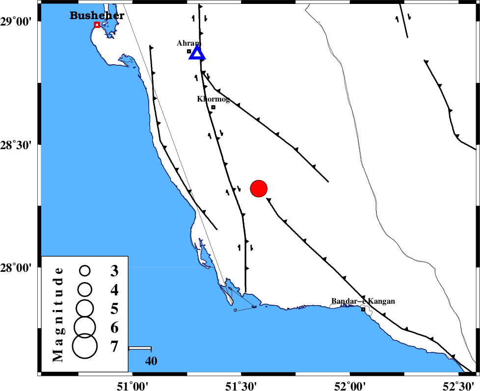
| Location | Lat:28.32 Lon: 51.58 |
| Region | Bushehr Province, 43 km South-East of Khormog |
Nearest Cities |
|
| 7 km of Kaki, Bushehr Province | |
| 12 km of Baduleh, Bushehr Province | |
| 18 km North of Abkesh, Bushehr Province | |
| 19 km West of Shanbeh, Bushehr Province | |
| 27 km North East of Ziyarat, Bushehr Province | |
| Depth | 7 km |
| Agency | |
Faults within 150 km: |
|
| MFF3 (Length: 292 km) , Distance to epicenter: 6 km | |
| BORAZJAN_F (Length: 168 km) , Distance to epicenter: 14 km | |
| MFF5 (Length: 74 km) , Distance to epicenter: 24 km | |
| Number of Phases | 7 |
| RMS | 0.3 |
| Number of Stations | 5 |
| Error in Latitude | >9.5 km |
| Error in Longitude | 9.1 km |
| Error in Depth | 4.6 km |
Download waveform in seisan format
to download seisan software Click here
to access information about IIEES stations Click here
Amplitude | ||||||||
| UID | Agency | Station | Component | Amplitude | Period | Arrival Time | Proccessing Time | Signal Clip |
| 91014 | IIEES | AHRM | N | 72786 | 0.56 | 2013-11-19 09:06:44 | 2013-11-19 09:32:00 | n |
| 91015 | IIEES | AHRM | E | 69560.6 | 0.52 | 2013-11-19 09:06:45 | 2013-11-19 09:32:00 | n |
Phase | ||||||||||||
| Agency | Station | Component | Phase Type | Phase Quality | First Motion | Observed Arrival Time | Time Residual | Loc. Flag | Input Weight | Distance | Azimuth | |
| IIEES | AHRM | Z | Pg | E | 2013-11-19 09:06:33 | -0.13 | y | 67 | 335 | |||
| IIEES | BNDS | Z | P | E | 2013-11-19 09:07:27 | -0.24 | y | 463 | 102 | |||
| IIEES | SHGR | Z | Pn | E | 2013-11-19 09:07:32 | 0.54 | y | 498 | 328 | |||
| IIEES | SHGR | N | S | E | 2013-11-19 09:08:22 | -0.41 | y | 498 | 328 | |||
| IIEES | KRBR | Z | Pn | E | 2013-11-19 09:07:37 | 0.14 | y | 537 | 69 | |||
| IIEES | KHMZ | Z | Pn | E | 2013-11-19 09:07:47 | 0.06 | y | 621 | 346 | |||
| IIEES | KHMZ | N | S | E | 2013-11-19 09:08:50 | 0.18 | y | 621 | 346 | |||