
Magnitude |
4.5 |
| Date & Time (UTC) | 2013-11-24 18:03:15.0 |
| Date & Time (Local) | 1392/9/3 21:33:15.0 |
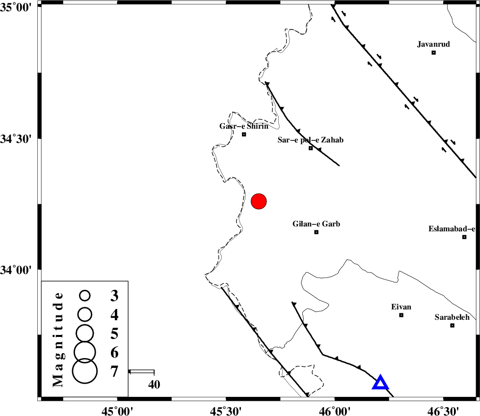
| Location | Lat:34.26 Lon: 45.65 |
| Region | Kermanshah Province, 29 km South of Qasr-E-Shirin |
Nearest Cities |
|
| 20 km West of Chub baghan, Kermanshah Province | |
| 21 km South of Seyyed sohrab, Kermanshah Province | |
| 23 km South East of Khosravi, Kermanshah Province | |
| 28 km North West of Gilan-E-Gharb, Kermanshah Province | |
| 28 km South West of Qareh belagh, Kermanshah Province | |
| Depth | 14 km |
| Agency | |
Faults within 150 km: |
|
| MFF8 (Length: 48 km) , Distance to epicenter: 33 km | |
| ZFF4 (Length: 128 km) , Distance to epicenter: 40 km | |
| MFF7 (Length: 99 km) , Distance to epicenter: 45 km | |
| Number of Phases | 6 |
| RMS | 0 |
| Number of Stations | 5 |
| Error in Latitude | >2.8 km |
| Error in Longitude | 13.1 km |
| Error in Depth | 12.3 km |
Download waveform in seisan format
to download seisan software Click here
to access information about IIEES stations Click here
Amplitude | ||||||||
| UID | Agency | Station | Component | Amplitude | Period | Arrival Time | Proccessing Time | Signal Clip |
| 91063 | IIEES | SHGR | N | 1132.8 | 0.52 | 2013-11-24 18:05:17 | 2013-11-24 06:30:00 | n |
| 91064 | IIEES | SHGR | E | 747.4 | 0.52 | 2013-11-24 18:05:26 | 2013-11-24 06:30:00 | n |
Phase | ||||||||||||
| Agency | Station | Component | Phase Type | Phase Quality | First Motion | Observed Arrival Time | Time Residual | Loc. Flag | Input Weight | Distance | Azimuth | |
| IIEES | SHGR | Z | P | E | 2013-11-24 18:04:09 | -0.01 | y | 378 | 128 | |||
| IIEES | SHGR | N | Sg | E | 2013-11-24 18:05:00 | -0.01 | y | 378 | 128 | |||
| IIEES | ZNJK | Z | Pn | E | 2013-11-24 18:04:10 | -0.03 | y | 384 | 45 | |||
| IIEES | KHMZ | Z | Pn | E | 2013-11-24 18:04:12 | 0.06 | y | 403 | 97 | |||
| IIEES | GHVR | Z | Pn | E | 2013-11-24 18:04:26 | -0.05 | y | 515 | 86 | |||
| IIEES | CHTH | Z | P | E | 2013-11-24 18:04:29 | 0.05 | y | 532 | 68 | |||