
Magnitude |
2.7 |
| Date & Time (UTC) | 2013-11-27 05:34:23.6 |
| Date & Time (Local) | 1392/9/6 09:04:23.6 |
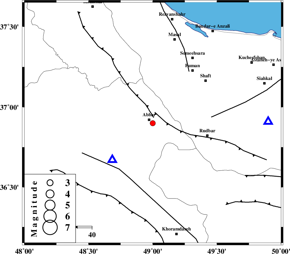
| Location | Lat:36.9 Lon: 49 |
| Region | Zanjan Province, 3 km Abbar |
Nearest Cities |
|
| 3 km of Abbar, Zanjan Province | |
| 6 km North of Void, Zanjan Province | |
| 15 km North East of Chorzag, Zanjan Province | |
| 24 km South East of Deram, Zanjan Province | |
| 24 km South West of Qaleh rudkhan, Gilan Province | |
| Depth | 14 km |
| Agency | |
Faults within 150 km: |
|
| MASULEL_F (Length: 90 km) , Distance to epicenter: 4 km | |
| RUDBAR_F (Length: 93 km) , Distance to epicenter: 8 km | |
| ZANJAN_F (Length: 137 km) , Distance to epicenter: 39 km | |
| Number of Phases | 7 |
| RMS | 0.3 |
| Number of Stations | 5 |
| Error in Latitude | >5.4 km |
| Error in Longitude | 3.2 km |
| Error in Depth | 9.7 km |
Download waveform in seisan format
to download seisan software Click here
to access information about IIEES stations Click here
Amplitude | ||||||||
| UID | Agency | Station | Component | Amplitude | Period | Arrival Time | Proccessing Time | Signal Clip |
| 91077 | IIEES | GHVR | N | 28.9 | 0.86 | 2013-11-27 05:36:05 | 2013-11-27 06:26:00 | n |
| 91078 | IIEES | GHVR | E | 17.7 | 0.6 | 2013-11-27 05:36:14 | 2013-11-27 06:26:00 | n |
Phase | ||||||||||||
| Agency | Station | Component | Phase Type | Phase Quality | First Motion | Observed Arrival Time | Time Residual | Loc. Flag | Input Weight | Distance | Azimuth | |
| IIEES | ZNJK | Z | Pg | E | 2013-11-27 05:34:30 | 0.02 | y | 37.9 | 227 | |||
| IIEES | ZNJK | E | Sg | E | 2013-11-27 05:34:36 | 0.02 | y | 37.9 | 227 | |||
| IIEES | CHTH | Z | Pn | E | 2013-11-27 05:34:58 | -0.36 | y | 220 | 119 | |||
| IIEES | CHTH | N | Sg | E | 2013-11-27 05:35:26 | -0.13 | y | 220 | 119 | |||
| IIEES | GRMI | Z | Pn | E | 2013-11-27 05:35:00 | -0.11 | y | 233 | 336 | |||
| IIEES | DAMV | Z | Pn | E | 2013-11-27 05:35:09 | 0.78 | y | 302 | 117 | |||
| IIEES | GHVR | Z | Pn | E | 2013-11-27 05:35:13 | -0.18 | y | 337 | 142 | |||