
Magnitude |
3 |
| Date & Time (UTC) | 2013-11-28 06:31:52.3 |
| Date & Time (Local) | 1392/9/7 10:01:52.3 |
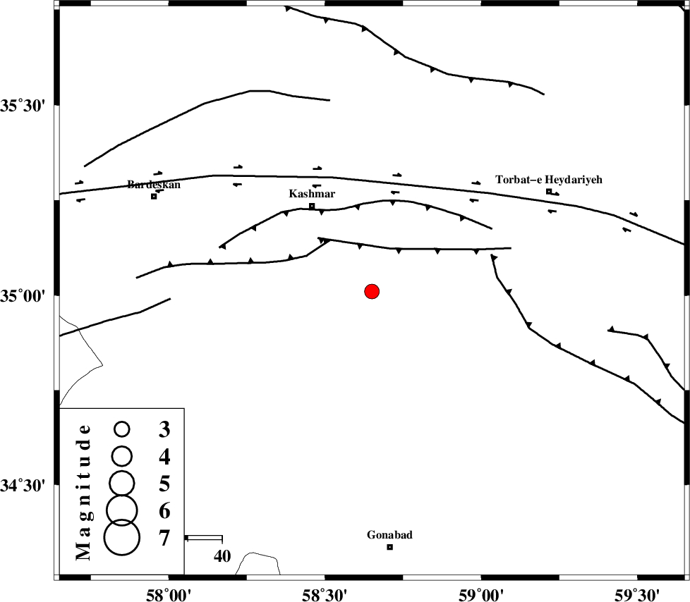
| Location | Lat:35.01 Lon: 58.65 |
| Region | Khorasan(center) Province, 31 km South-East of Kashmar |
Nearest Cities |
|
| 12 km West of Feizabad, Khorasan(center) Province | |
| 18 km North West of Mahneh, Khorasan(center) Province | |
| 30 km North East of Yoonesi, Khorasan(center) Province | |
| 31 km South East of Kashmar, Khorasan(center) Province | |
| 35 km South East of Kasrineh, Khorasan(center) Province | |
| Depth | 44 km |
| Agency | |
Faults within 150 km: |
|
| DUGHABAD_F (Length: 62 km) , Distance to epicenter: 14 km | |
| MEHDIABAD_F (Length: 64 km) , Distance to epicenter: 19 km | |
| KASHMAR_F (Length: 91 km) , Distance to epicenter: 26 km | |
| Number of Phases | 7 |
| RMS | 0 |
| Number of Stations | 5 |
| Error in Latitude | >2.3 km |
| Error in Longitude | 1.2 km |
| Error in Depth | 2.8 km |
Download waveform in seisan format
to download seisan software Click here
to access information about IIEES stations Click here
Amplitude | ||||||||
| UID | Agency | Station | Component | Amplitude | Period | Arrival Time | Proccessing Time | Signal Clip |
| 91090 | IIEES | TABS | N | 104.4 | 0.56 | 2013-11-28 06:32:53 | 2013-11-28 08:01:00 | n |
| 91091 | IIEES | SHRT | E | 150.5 | 0.4 | 2013-11-28 06:32:52 | 2013-11-28 08:01:00 | n |
| 91092 | IIEES | SHRT | N | 90.8 | 0.28 | 2013-11-28 06:32:53 | 2013-11-28 08:01:00 | n |
Phase | ||||||||||||
| Agency | Station | Component | Phase Type | Phase Quality | First Motion | Observed Arrival Time | Time Residual | Loc. Flag | Input Weight | Distance | Azimuth | |
| IIEES | TABS | Z | Pn | E | 2013-11-28 06:32:22 | 0.02 | y | 206 | 224 | |||
| IIEES | TABS | N | Sg | E | 2013-11-28 06:32:50 | 0.03 | y | 206 | 224 | |||
| IIEES | SHRT | Z | Pn | E | 2013-11-28 06:32:23 | 0.06 | y | 213 | 135 | |||
| IIEES | SHRT | N | Sg | E | 2013-11-28 06:32:51 | -0.03 | y | 213 | 135 | |||
| IIEES | SHRO | E | Pn | E | 2013-11-28 06:32:30 | 0 | y | 264 | 296 | |||
| IIEES | BSRN | Z | Pn | E | 2013-11-28 06:32:39 | -0.03 | y | 340 | 172 | |||
| IIEES | YZKH | Z | Pn | E | 2013-11-28 06:32:56 | -0.09 | y | 475 | 234 | |||