
Magnitude |
3.2 |
| Date & Time (UTC) | 2013-11-28 20:57:28.0 |
| Date & Time (Local) | 1392/9/8 00:27:28.0 |
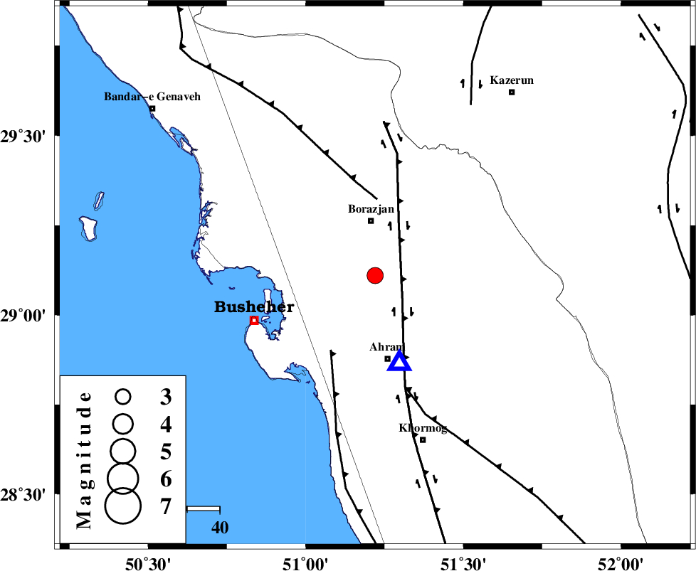
| Location | Lat:29.11 Lon: 51.22 |
| Region | Bushehr Province, 17 km South of Borazjan |
Nearest Cities |
|
| 9 km of Sarkareh, Bushehr Province | |
| 17 km South of Borazjan, Bushehr Province | |
| 19 km North of Bazuei, Bushehr Province | |
| 23 km North East of Choghadak, Bushehr Province | |
| 24 km South East of Ziyarat, Bushehr Province | |
| Depth | 15 km |
| Agency | |
Faults within 150 km: |
|
| BORAZJAN_F (Length: 168 km) , Distance to epicenter: 11 km | |
| ZFF3 (Length: 125 km) , Distance to epicenter: 24 km | |
| ZFF2 (Length: 84 km) , Distance to epicenter: 27 km | |
| Number of Phases | 4 |
| RMS | 0 |
| Number of Stations | 4 |
| Error in Latitude | >10 km |
| Error in Longitude | 1.6 km |
| Error in Depth | 0 km |
Download waveform in seisan format
to download seisan software Click here
to access information about IIEES stations Click here
Amplitude | ||||||||
| UID | Agency | Station | Component | Amplitude | Period | Arrival Time | Proccessing Time | Signal Clip |
| 91101 | IIEES | KRBR | E | 18.3 | 0.52 | 2013-11-28 21:00:08 | 2013-11-29 01:38:00 | n |
| 91102 | IIEES | KRBR | N | 14.7 | 0.6 | 2013-11-28 21:00:10 | 2013-11-29 01:38:00 | n |
| 91103 | IIEES | ASAO | E | 9.4 | 0.56 | 2013-11-28 21:00:32 | 2013-11-29 01:38:00 | n |
Phase | ||||||||||||
| Agency | Station | Component | Phase Type | Phase Quality | First Motion | Observed Arrival Time | Time Residual | Loc. Flag | Input Weight | Distance | Azimuth | |
| IIEES | YZKH | Z | Pn | E | 2013-11-28 20:58:36 | 0 | y | 487 | 41 | |||
| IIEES | KHMZ | Z | Pn | E | 2013-11-28 20:58:41 | 0.02 | y | 528 | 347 | |||
| IIEES | KRBR | Z | Pn | E | 2013-11-28 20:58:43 | 0 | y | 546 | 78 | |||
| IIEES | ASAO | Z | Pn | E | 2013-11-28 20:58:52 | -0.03 | y | 614 | 350 | |||