
Magnitude |
3.3 |
| Date & Time (UTC) | 2013-12-01 11:22:31.3 |
| Date & Time (Local) | 1392/9/10 14:52:31.3 |
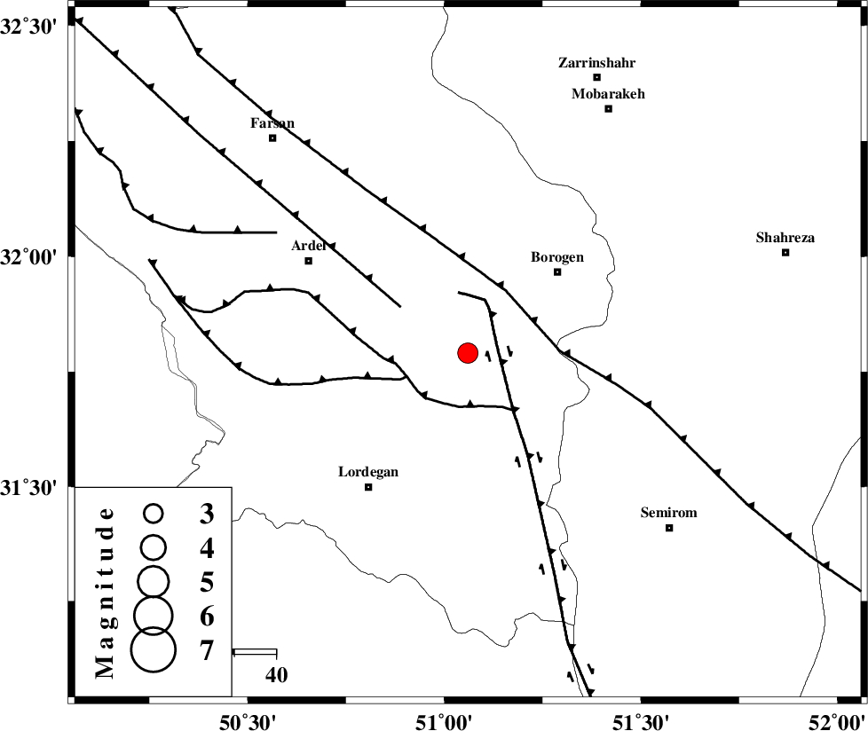
| Location | Lat:31.79 Lon: 51.06 |
| Region | Chaharmahal Bakhtiari Province, 30 km South-West of Borujen |
Nearest Cities |
|
| 12 km of Gandoman, Chaharmahal Bakhtiari Province | |
| 15 km South of Baladaji, Chaharmahal Bakhtiari Province | |
| 26 km South West of Faradonbeh, Chaharmahal Bakhtiari Province | |
| 27 km North of Aluni, Chaharmahal Bakhtiari Province | |
| 29 km South West of Borujen, Chaharmahal Bakhtiari Province | |
| Depth | 18 km |
| Agency | |
Faults within 150 km: |
|
| DENA_F (Length: 137 km) , Distance to epicenter: 7 km | |
| DOPOLAN_F (Length: 107 km) , Distance to epicenter: 13 km | |
| SABZKUH_F (Length: 67 km) , Distance to epicenter: 16 km | |
| Number of Phases | 8 |
| RMS | 0.2 |
| Number of Stations | 6 |
| Error in Latitude | >2.8 km |
| Error in Longitude | 3.6 km |
| Error in Depth | 7.7 km |
Download waveform in seisan format
to download seisan software Click here
to access information about IIEES stations Click here
Amplitude | ||||||||
| UID | Agency | Station | Component | Amplitude | Period | Arrival Time | Proccessing Time | Signal Clip |
| 91128 | IIEES | SHGR | N | 246 | 0.64 | 2013-12-01 11:23:50 | 2013-12-01 11:56:00 | n |
| 91129 | IIEES | SHGR | E | 203.3 | 0.68 | 2013-12-01 11:23:52 | 2013-12-01 11:56:00 | n |
Phase | ||||||||||||
| Agency | Station | Component | Phase Type | Phase Quality | First Motion | Observed Arrival Time | Time Residual | Loc. Flag | Input Weight | Distance | Azimuth | |
| IIEES | SHGR | Z | Pn | E | 2013-12-01 11:23:05 | 0.21 | y | 216 | 280 | |||
| IIEES | KHMZ | Z | Pn | E | 2013-12-01 11:23:08 | 0 | y | 240 | 335 | |||
| IIEES | GHVR | Z | Pn | E | 2013-12-01 11:23:15 | 0.14 | y | 299 | 3 | |||
| IIEES | GHVR | E | Sg | E | 2013-12-01 11:23:55 | 0.29 | y | 299 | 3 | |||
| IIEES | ASAO | Z | Pn | E | 2013-12-01 11:23:18 | -0.38 | y | 321 | 343 | |||
| IIEES | ASAO | E | Sg | E | 2013-12-01 11:24:01 | -0.23 | y | 321 | 343 | |||
| IIEES | AHRM | Z | P | E | 2013-12-01 11:23:18 | 0 | y | 325 | 176 | |||
| IIEES | YZKH | Z | Pn | E | 2013-12-01 11:23:21 | -0.08 | y | 340 | 78 | |||