
Magnitude |
2 |
| Date & Time (UTC) | 2013-12-03 19:56:05.8 |
| Date & Time (Local) | 1392/9/12 23:26:05.8 |
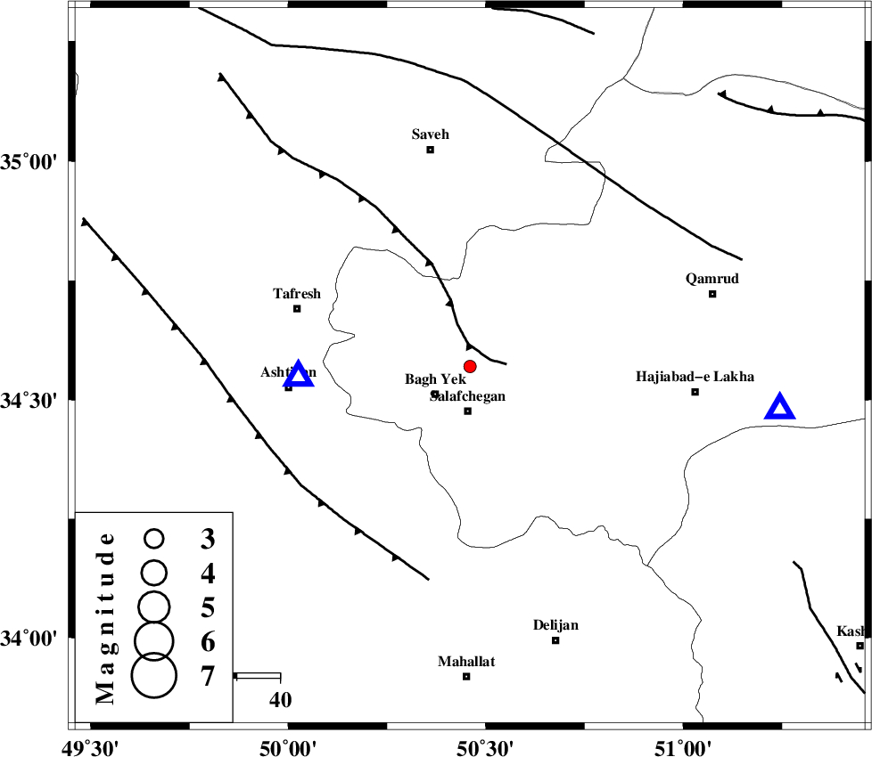
| Location | Lat:34.57 Lon: 50.46 |
| Region | Qom Province, 38 km West of Qom |
Nearest Cities |
|
| 10 km North of Bagh yek, Qom Province | |
| 10 km North of Salafchegan, Qom Province | |
| 20 km North East of Dastjerd, Qom Province | |
| 24 km South of Gazran, Qom Province | |
| 32 km North East of Salehabad, Markazi Province | |
| Depth | 14 km |
| Agency | |
Faults within 150 km: |
|
| INDES_F (Length: 98 km) , Distance to epicenter: 5 km | |
| TAFRESH_F (Length: 117 km) , Distance to epicenter: 46 km | |
| KUSHK_E_NOSRAT_F (Length: 230 km) , Distance to epicenter: 55 km | |
| Number of Phases | 5 |
| RMS | 0.1 |
| Number of Stations | 5 |
| Error in Latitude | >1.7 km |
| Error in Longitude | 2.2 km |
| Error in Depth | 9.8 km |
Download waveform in seisan format
to download seisan software Click here
to access information about IIEES stations Click here
Amplitude | ||||||||
| UID | Agency | Station | Component | Amplitude | Period | Arrival Time | Proccessing Time | Signal Clip |
| 91142 | IIEES | DAMV | E | 17.5 | 0.2 | 2013-12-03 19:56:59 | 2013-12-03 09:33:00 | n |
Phase | ||||||||||||
| Agency | Station | Component | Phase Type | Phase Quality | First Motion | Observed Arrival Time | Time Residual | Loc. Flag | Input Weight | Distance | Azimuth | |
| IIEES | ASAO | Z | Pg | E | 2013-12-03 19:56:13 | 0.1 | y | 40.1 | 267 | |||
| IIEES | ASAO | E | Sg | E | 2013-12-03 19:56:19 | -0.02 | y | 40.1 | 267 | |||
| IIEES | GHVR | Z | Pg | E | 2013-12-03 19:56:18 | 0.06 | y | 72.6 | 97 | |||
| IIEES | KHMZ | Z | Pg | E | 2013-12-03 19:56:23 | -0.08 | y | 103 | 207 | |||
| IIEES | CHTH | Z | Pg | E | 2013-12-03 19:56:33 | -0.07 | y | 161 | 22 | |||