
Magnitude |
2.8 |
| Date & Time (UTC) | 2013-12-06 12:09:28.0 |
| Date & Time (Local) | 1392/9/15 15:39:28.0 |
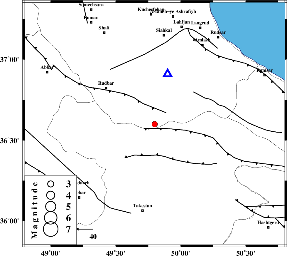
| Location | Lat:36.6 Lon: 49.8 |
| Region | Gilan Province, 41 km North-West of Qazvin |
Nearest Cities |
|
| 11 km South of Jirhandeh, Gilan Province | |
| 21 km South West of Kelishom, Gilan Province | |
| 23 km North East of Kuhgir-e sofla, Ghazvin Province | |
| 25 km East of Loshan, Gilan Province | |
| 29 km North of Aqababa, Ghazvin Province | |
| Depth | 14 km |
| Agency | |
Faults within 150 km: |
|
| ALAMUTRUD_F (Length: 140 km) , Distance to epicenter: 7 km | |
| RUDBAR_F (Length: 93 km) , Distance to epicenter: 11 km | |
| N_QAZVIN_F (Length: 72 km) , Distance to epicenter: 21 km | |
| Number of Phases | 6 |
| RMS | 0.1 |
| Number of Stations | 4 |
| Error in Latitude | >1.8 km |
| Error in Longitude | 3.9 km |
| Error in Depth | 4.9 km |
Download waveform in seisan format
to download seisan software Click here
to access information about IIEES stations Click here
Amplitude | ||||||||
| UID | Agency | Station | Component | Amplitude | Period | Arrival Time | Proccessing Time | Signal Clip |
| 91156 | IIEES | GHVR | E | 41.9 | 0.48 | 2013-12-06 12:10:50 | 2013-12-06 12:48:00 | n |
| 91157 | IIEES | GHVR | N | 47.8 | 0.68 | 2013-12-06 12:10:55 | 2013-12-06 12:48:00 | n |
Phase | ||||||||||||
| Agency | Station | Component | Phase Type | Phase Quality | First Motion | Observed Arrival Time | Time Residual | Loc. Flag | Input Weight | Distance | Azimuth | |
| IIEES | CHTH | Z | Pg | E | 2013-12-06 12:09:51 | -0.08 | y | 142 | 123 | |||
| IIEES | ASAO | Z | Pn | E | 2013-12-06 12:10:04 | -0.14 | y | 229 | 175 | |||
| IIEES | ASAO | N | Sg | E | 2013-12-06 12:10:33 | 0.01 | y | 229 | 175 | |||
| IIEES | GHVR | Z | Pn | E | 2013-12-06 12:10:09 | 0.2 | y | 269 | 150 | |||
| IIEES | GHVR | N | Sg | E | 2013-12-06 12:10:43 | 0.02 | y | 269 | 150 | |||
| IIEES | GRMI | Z | Pn | E | 2013-12-06 12:10:12 | -0.01 | y | 297 | 326 | |||