
Magnitude |
4.2 |
| Date & Time (UTC) | 2013-12-07 23:12:42.5 |
| Date & Time (Local) | 1392/9/17 02:42:42.5 |
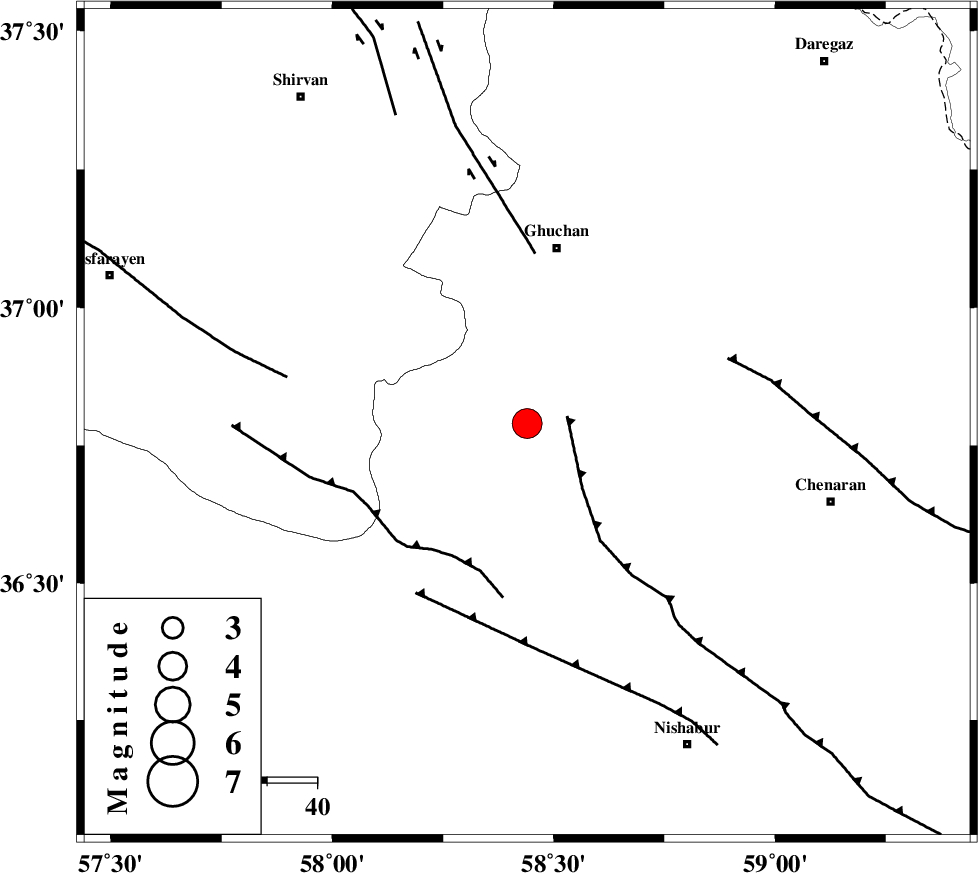
| Location | Lat:36.79 Lon: 58.44 |
| Region | Khorasan(center) Province, 36 km South of Quchan |
Nearest Cities |
|
| 6 km of Chakaneh, Khorasan(center) Province | |
| 11 km North of Abdollahgiv, Khorasan(center) Province | |
| 26 km South East of Yangi qaleh, Khorasan(center) Province | |
| 30 km North West of Kalateh mohammadkhan, Khorasan(center) Province | |
| 33 km South West of Ali Abad, Khorasan(center) Province | |
| Depth | 14 km |
| Agency | |
Faults within 150 km: |
|
| BINALUD_F1 (Length: 129 km) , Distance to epicenter: 8 km | |
| RIVAND_F (Length: 70 km) , Distance to epicenter: 31 km | |
| GHUCHAN_F (Length: 50 km) , Distance to epicenter: 34 km | |
| Number of Phases | 6 |
| RMS | 0.1 |
| Number of Stations | 6 |
| Error in Latitude | >7.2 km |
| Error in Longitude | 5.8 km |
| Error in Depth | 15.5 km |
Download waveform in seisan format
to download seisan software Click here
to access information about IIEES stations Click here
Amplitude | ||||||||
| UID | Agency | Station | Component | Amplitude | Period | Arrival Time | Proccessing Time | Signal Clip |
| 91164 | IIEES | YZKH | E | 106 | 0.68 | 2013-12-07 23:15:51 | 2013-12-07 11:56:00 | n |
| 91165 | IIEES | KRBR | E | 49 | 0.76 | 2013-12-07 23:16:31 | 2013-12-07 11:56:00 | n |
Phase | ||||||||||||
| Agency | Station | Component | Phase Type | Phase Quality | First Motion | Observed Arrival Time | Time Residual | Loc. Flag | Input Weight | Distance | Azimuth | |
| IIEES | BJRD | Z | Pg | E | 2013-12-07 23:13:05 | -0.16 | y | 137 | 318 | |||
| IIEES | BJRD | E | Sg | E | 2013-12-07 23:13:22 | 0.15 | y | 137 | 318 | |||
| IIEES | SHRO | E | Pn | E | 2013-12-07 23:13:19 | -0.08 | y | 234 | 249 | |||
| IIEES | TABS | Z | Pn | E | 2013-12-07 23:13:36 | 0.03 | y | 368 | 199 | |||
| IIEES | SHRT | Z | Pn | E | 2013-12-07 23:13:38 | 0.07 | y | 387 | 154 | |||
| IIEES | YZKH | Z | Pn | E | 2013-12-07 23:14:05 | 0.02 | y | 602 | 217 | |||