
Magnitude |
3.2 |
| Date & Time (UTC) | 2013-12-14 08:14:16.7 |
| Date & Time (Local) | 1392/9/23 11:44:16.7 |
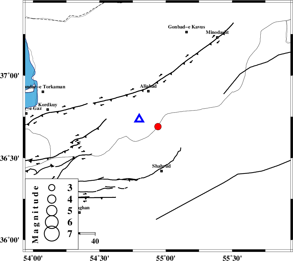
| Location | Lat:36.69 Lon: 54.94 |
| Region | Golestan Province, 24 km South of Ali Abad |
Nearest Cities |
|
| 16 km North West of Qaleh-ye nokharqan, Semnan Province | |
| 24 km North of Bastam, Semnan Province | |
| 25 km South of Ali Abad, Golestan Province | |
| 30 km North of Shahrud, Semnan Province | |
| 33 km North West of Kalateh khanj, Semnan Province | |
| Depth | 14 km |
| Agency | |
Faults within 150 km: |
|
| SHAVAR_F (Length: 87 km) , Distance to epicenter: 12 km | |
| KHAZAR_F (Length: 523 km) , Distance to epicenter: 35 km | |
| ASTANEH_F (Length: 72 km) , Distance to epicenter: 38 km | |
| Number of Phases | 8 |
| RMS | 0.2 |
| Number of Stations | 7 |
| Error in Latitude | >3.3 km |
| Error in Longitude | 2.5 km |
| Error in Depth | 8.4 km |
Download waveform in seisan format
to download seisan software Click here
to access information about IIEES stations Click here
Amplitude | ||||||||
| UID | Agency | Station | Component | Amplitude | Period | Arrival Time | Proccessing Time | Signal Clip |
| 91207 | IIEES | DAMV | E | 128.5 | 0.57 | 2013-12-14 08:15:41 | 2013-12-14 09:30:00 | n |
| 91208 | IIEES | GHVR | E | 38.1 | 0.53 | 2013-12-14 08:16:18 | 2013-12-14 09:30:00 | n |
Phase | ||||||||||||
| Agency | Station | Component | Phase Type | Phase Quality | First Motion | Observed Arrival Time | Time Residual | Loc. Flag | Input Weight | Distance | Azimuth | |
| IIEES | BJRD | Z | Pn | E | 2013-12-14 08:14:55 | 0.06 | y | 246 | 62 | |||
| IIEES | BJRD | N | Sg | E | 2013-12-14 08:15:26 | -0.05 | y | 246 | 62 | |||
| IIEES | DAMV | Z | Pn | E | 2013-12-14 08:15:00 | -0.24 | y | 292 | 247 | |||
| IIEES | CHTH | Z | Pn | E | 2013-12-14 08:15:08 | 0.05 | y | 353 | 257 | |||
| IIEES | TABS | Z | Pn | E | 2013-12-14 08:15:13 | 0.1 | y | 392 | 149 | |||
| IIEES | GHVR | Z | Pn | E | 2013-12-14 08:15:16 | 0.29 | y | 415 | 235 | |||
| IIEES | YZKH | Z | Pn | E | 2013-12-14 08:15:23 | -0.2 | y | 478 | 184 | |||
| IIEES | SHRT | Z | Pn | E | 2013-12-14 08:15:38 | 0.01 | y | 593 | 123 | |||