
Magnitude |
3.5 |
| Date & Time (UTC) | 2013-12-14 14:38:50.2 |
| Date & Time (Local) | 1392/9/23 18:08:50.2 |
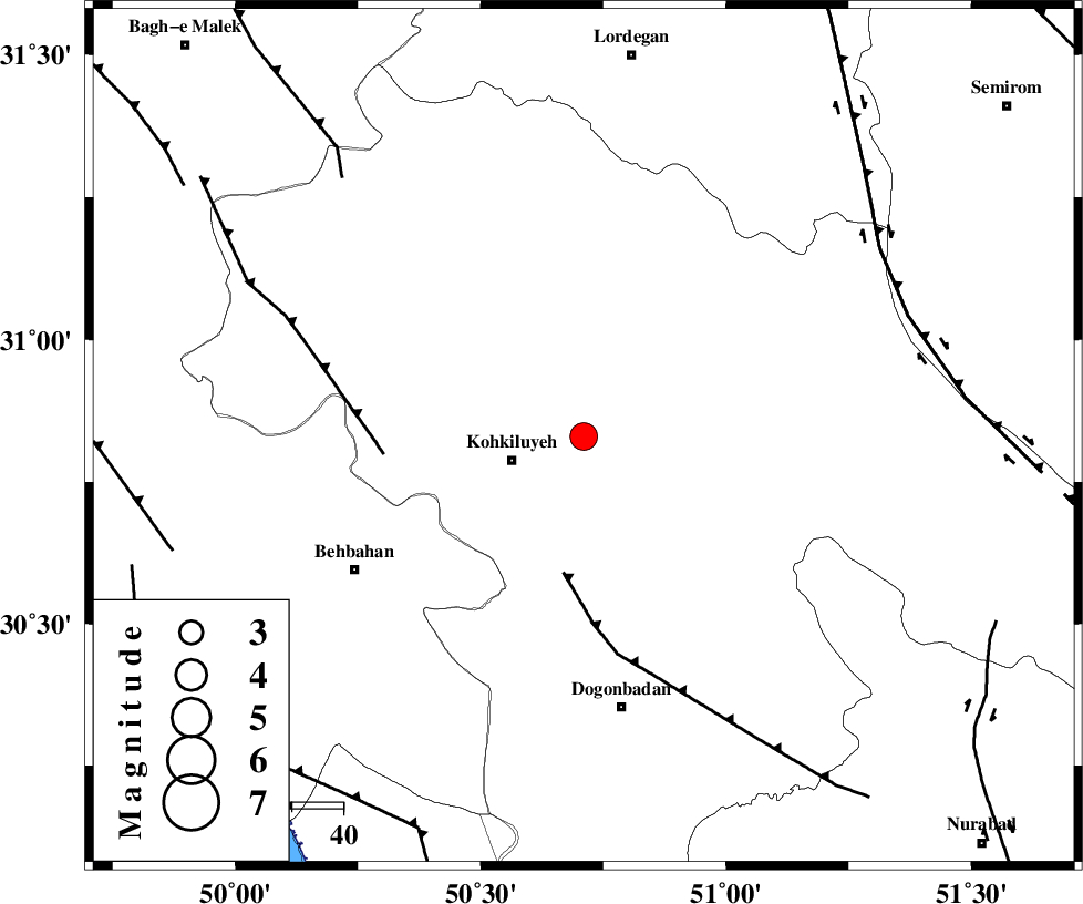
| Location | Lat:30.83 Lon: 50.71 |
| Region | Kohkiluieh va boyerahmad Province, 15 km East of Dehdasht |
Nearest Cities |
|
| 9 km of Savari, Kohkiluieh va boyerahmad Province | |
| 15 km North East of Dehdasht, Kohkiluieh va boyerahmad Province | |
| 32 km South East of Lendeh, Kohkiluieh va boyerahmad Province | |
| 39 km South West of Margun, Kohkiluieh va boyerahmad Province | |
| 45 km North East of Mansuriyeh, Khoozestan Province | |
| Depth | 14 km |
| Agency | |
Faults within 150 km: |
|
| MISHAN_F (Length: 76 km) , Distance to epicenter: 27 km | |
| MFF4 (Length: 62 km) , Distance to epicenter: 39 km | |
| DENA_F (Length: 137 km) , Distance to epicenter: 67 km | |
| Number of Phases | 7 |
| RMS | 0.1 |
| Number of Stations | 5 |
| Error in Latitude | >4.1 km |
| Error in Longitude | 7.2 km |
| Error in Depth | 10.6 km |
Download waveform in seisan format
to download seisan software Click here
to access information about IIEES stations Click here
Amplitude | ||||||||
| UID | Agency | Station | Component | Amplitude | Period | Arrival Time | Proccessing Time | Signal Clip |
| 91212 | IIEES | SHGR | E | 338 | 0.76 | 2013-12-14 14:40:00 | 2013-12-14 03:19:00 | n |
Phase | ||||||||||||
| Agency | Station | Component | Phase Type | Phase Quality | First Motion | Observed Arrival Time | Time Residual | Loc. Flag | Input Weight | Distance | Azimuth | |
| IIEES | AHRM | Z | Pg | E | 2013-12-14 14:39:26 | 0.02 | y | 225 | 165 | |||
| IIEES | AHRM | N | Sg | E | 2013-12-14 14:39:53 | 0.03 | y | 225 | 165 | |||
| IIEES | SHGR | Z | Pg | E | 2013-12-14 14:39:27 | -0.17 | y | 231 | 308 | |||
| IIEES | SHGR | N | Sg | E | 2013-12-14 14:39:55 | 0.11 | y | 231 | 308 | |||
| IIEES | KHMZ | Z | Pn | E | 2013-12-14 14:39:39 | 0.04 | y | 330 | 348 | |||
| IIEES | GHVR | Z | Pn | E | 2013-12-14 14:39:48 | 0.01 | y | 408 | 7 | |||
| IIEES | DAMV | Z | Pn | E | 2013-12-14 14:40:05 | -0.06 | y | 545 | 12 | |||