
Magnitude |
3.6 |
| Date & Time (UTC) | 2013-12-18 10:59:56.3 |
| Date & Time (Local) | 1392/9/27 14:29:56.3 |
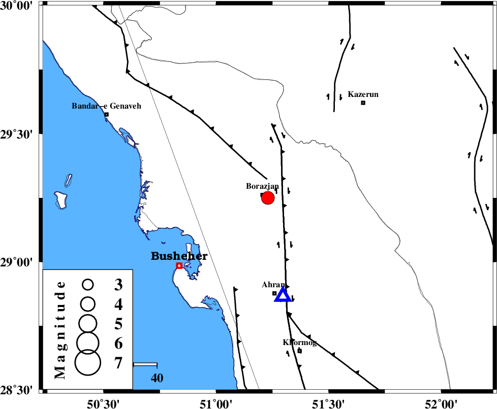
| Location | Lat:29.25 Lon: 51.23 |
| Region | Bushehr Province, 2 km Borazjan |
Nearest Cities |
|
| 3 km of Borazjan, Bushehr Province | |
| 7 km North of Sarkareh, Bushehr Province | |
| 14 km South of Nazar aqa, Bushehr Province | |
| 16 km East of Ziyarat, Bushehr Province | |
| 18 km South East of Saedabad, Bushehr Province | |
| Depth | 6 km |
| Agency | |
Faults within 150 km: |
|
| BORAZJAN_F (Length: 168 km) , Distance to epicenter: 7 km | |
| ZFF3 (Length: 125 km) , Distance to epicenter: 8 km | |
| ZFF2 (Length: 84 km) , Distance to epicenter: 41 km | |
| Number of Phases | 6 |
| RMS | 0 |
| Number of Stations | 5 |
| Error in Latitude | >3.4 km |
| Error in Longitude | 3.5 km |
| Error in Depth | 10 km |
Download waveform in seisan format
to download seisan software Click here
to access information about IIEES stations Click here
Amplitude | ||||||||
| UID | Agency | Station | Component | Amplitude | Period | Arrival Time | Proccessing Time | Signal Clip |
| 91230 | IIEES | ASAO | N | 26 | 0.48 | 2013-12-18 11:02:24 | 2013-12-18 11:44:00 | n |
| 91231 | IIEES | ASAO | E | 34.5 | 0.56 | 2013-12-18 11:02:24 | 2013-12-18 11:44:00 | n |
Phase | ||||||||||||
| Agency | Station | Component | Phase Type | Phase Quality | First Motion | Observed Arrival Time | Time Residual | Loc. Flag | Input Weight | Distance | Azimuth | |
| IIEES | AHRM | Z | Pg | E | 2013-12-18 11:00:04 | 0 | y | 43.2 | 171 | |||
| IIEES | AHRM | E | Sg | E | 2013-12-18 11:00:09 | 0 | y | 43.2 | 171 | |||
| IIEES | SHGR | Z | Pn | E | 2013-12-18 11:00:53 | 0 | y | 393 | 324 | |||
| IIEES | YZKH | Z | Pn | E | 2013-12-18 11:01:04 | 0 | y | 474 | 42 | |||
| IIEES | KHMZ | Z | Pn | E | 2013-12-18 11:01:08 | -0.04 | y | 512 | 347 | |||
| IIEES | ASAO | Z | Pn | E | 2013-12-18 11:01:19 | 0.05 | y | 598 | 349 | |||