
Magnitude |
3.3 |
| Date & Time (UTC) | 2013-12-29 05:12:50.9 |
| Date & Time (Local) | 1392/10/8 08:42:50.9 |
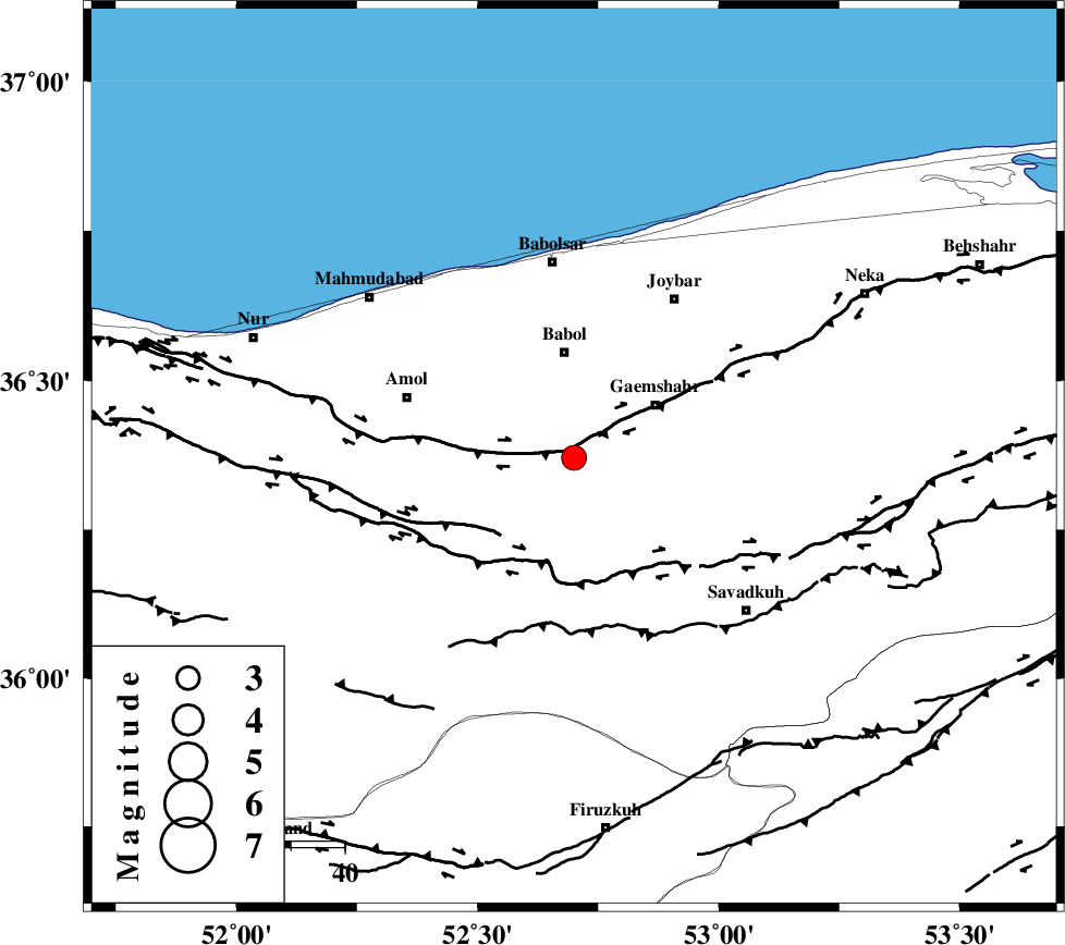
| Location | Lat:36.37 Lon: 52.7 |
| Region | Mazandaran Province, 19 km South of Babol |
Nearest Cities |
|
| 5 km North of Derazkola, Mazandaran Province | |
| 13 km of Paeen-e ahmad chalehpey, Mazandaran Province | |
| 14 km North East of Khoshrud, Mazandaran Province | |
| 15 km North West of Kij khalil, Mazandaran Province | |
| 18 km West of Qaemshahr, Mazandaran Province | |
| Depth | 15 km |
| Agency | |
Faults within 150 km: |
|
| KHAZAR_F (Length: 523 km) , Distance to epicenter: 0 km | |
| N_ALBORZ_F (Length: 360 km) , Distance to epicenter: 21 km | |
| MOSHA_F (Length: 234 km) , Distance to epicenter: 76 km | |
| Number of Phases | 7 |
| RMS | 0.2 |
| Number of Stations | 6 |
| Error in Latitude | >3.7 km |
| Error in Longitude | 7.2 km |
| Error in Depth | 7.9 km |
Download waveform in seisan format
to download seisan software Click here
to access information about IIEES stations Click here
Amplitude | ||||||||
| UID | Agency | Station | Component | Amplitude | Period | Arrival Time | Proccessing Time | Signal Clip |
| 91303 | IIEES | GHVR | E | 195.8 | 0.45 | 2013-12-29 05:14:04 | 2013-12-29 06:49:00 | n |
| 91304 | IIEES | GHVR | N | 174.3 | 0.68 | 2013-12-29 05:14:04 | 2013-12-29 06:49:00 | n |
Phase | ||||||||||||
| Agency | Station | Component | Phase Type | Phase Quality | First Motion | Observed Arrival Time | Time Residual | Loc. Flag | Input Weight | Distance | Azimuth | |
| IIEES | CHTH | Z | Pg | E | 2013-12-29 05:13:16 | 0.04 | y | 151 | 250 | |||
| IIEES | CHTH | N | Sg | E | 2013-12-29 05:13:34 | -0.04 | y | 151 | 250 | |||
| IIEES | GHVR | Z | Pn | E | 2013-12-29 05:13:29 | -0.31 | y | 248 | 213 | |||
| IIEES | ASAO | Z | Pn | E | 2013-12-29 05:13:38 | 0.2 | y | 316 | 231 | |||
| IIEES | ZNJK | Z | Pn | E | 2013-12-29 05:13:43 | -0.06 | y | 361 | 276 | |||
| IIEES | KHMZ | Z | P | E | 2013-12-29 05:13:46 | 0.24 | y | 384 | 221 | |||
| IIEES | GRMI | Z | P | E | 2013-12-29 05:14:01 | -0.02 | y | 503 | 304 | |||