
Magnitude |
3.2 |
| Date & Time (UTC) | 2014-01-01 11:01:27.6 |
| Date & Time (Local) | 1392/10/11 14:31:27.6 |
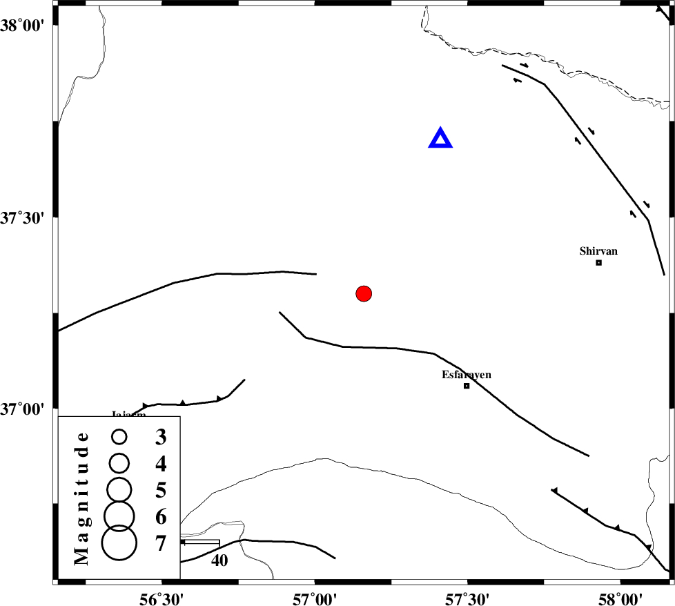
| Location | Lat:37.3 Lon: 57.16 |
| Region | Khorasan(north) Province, 25 km South-West of Bojnurd |
Nearest Cities |
|
| 20 km North of Cheharborj, Khorasan(north) Province | |
| 24 km South West of Void, Khorasan(north) Province | |
| 24 km South West of Bojnurd, Khorasan(north) Province | |
| 29 km East of Shogan, Khorasan(north) Province | |
| 30 km North West of Zarqabad, Khorasan(north) Province | |
| Depth | 14 km |
| Agency | |
Faults within 150 km: |
|
| ROBATE_QARABIL_F (Length: 168 km) , Distance to epicenter: 15 km | |
| ESFARAYEN_F (Length: 111 km) , Distance to epicenter: 17 km | |
| JAJARAM_F (Length: 77 km) , Distance to epicenter: 43 km | |
| Number of Phases | 8 |
| RMS | 0.2 |
| Number of Stations | 7 |
| Error in Latitude | >2.7 km |
| Error in Longitude | 4.5 km |
| Error in Depth | 4.8 km |
Download waveform in seisan format
to download seisan software Click here
to access information about IIEES stations Click here
Amplitude | ||||||||
| UID | Agency | Station | Component | Amplitude | Period | Arrival Time | Proccessing Time | Signal Clip |
| 91346 | IIEES | SHRO | E | 263.7 | 0.53 | 2014-01-01 11:02:24 | 2014-01-01 11:26:00 | n |
| 91347 | IIEES | YZKH | N | 11.3 | 0.48 | 2014-01-01 11:04:19 | 2014-01-01 11:26:00 | n |
| 91348 | IIEES | YZKH | E | 13.6 | 0.68 | 2014-01-01 11:04:34 | 2014-01-01 11:26:00 | n |
Phase | ||||||||||||
| Agency | Station | Component | Phase Type | Phase Quality | First Motion | Observed Arrival Time | Time Residual | Loc. Flag | Input Weight | Distance | Azimuth | |
| IIEES | BJRD | Z | Pg | E | 2014-01-01 11:01:36 | -0.09 | y | 49.9 | 26 | |||
| IIEES | SHRO | E | Pg | E | 2014-01-01 11:01:56 | -0.33 | y | 176 | 216 | |||
| IIEES | SHRO | E | Sg | E | 2014-01-01 11:02:17 | -0.04 | y | 176 | 216 | |||
| IIEES | TABS | Z | Pn | E | 2014-01-01 11:02:25 | 0.12 | y | 405 | 181 | |||
| IIEES | SHRT | Z | Pn | E | 2014-01-01 11:02:36 | -0.08 | y | 495 | 144 | |||
| IIEES | DAMV | Z | Pn | E | 2014-01-01 11:02:37 | 0.32 | y | 500 | 250 | |||
| IIEES | YZKH | Z | Pn | E | 2014-01-01 11:02:49 | 0.22 | y | 593 | 204 | |||
| IIEES | BSRN | Z | Pn | E | 2014-01-01 11:02:52 | 0.16 | y | 618 | 162 | |||