
Magnitude |
5.6 |
| Date & Time (UTC) | 2014-01-02 03:13:56.9 |
| Date & Time (Local) | 1392/10/12 06:43:56.9 |
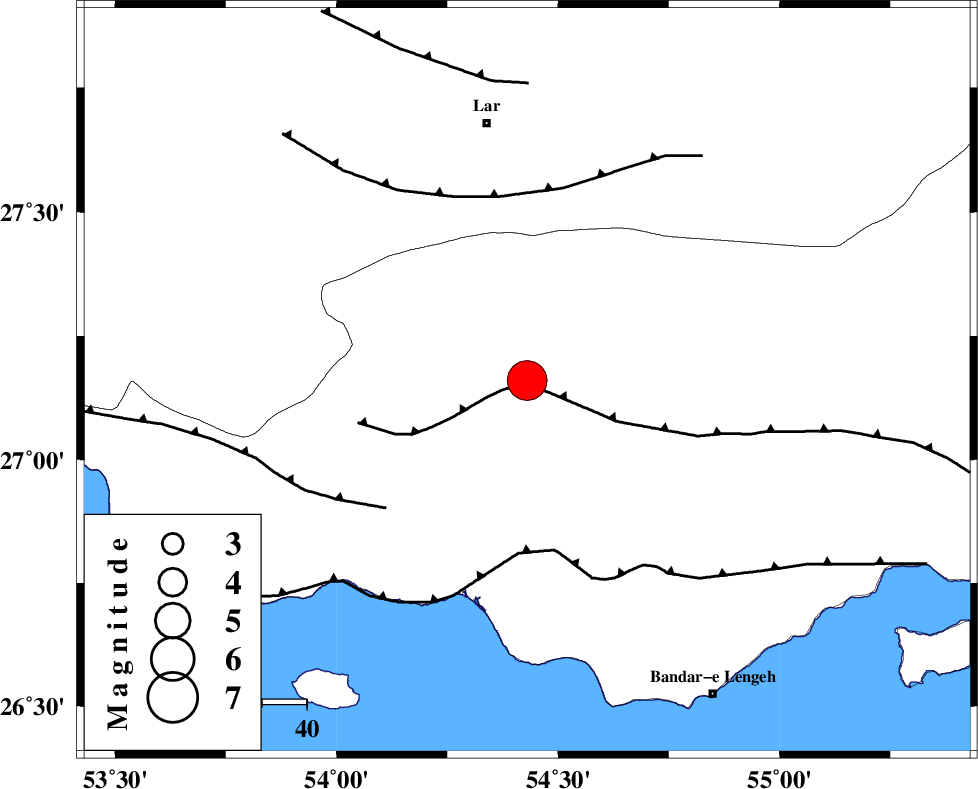
| Location | Lat:27.16 Lon: 54.43 |
| Region | Hormozgan Province, 8 km Bastak |
Nearest Cities |
|
| 8 km of Bastak, Hormozgan Province | |
| 22 km North East of Jenah, Hormozgan Province | |
| 54 km South East of Bagh, Fars Province | |
| 58 km South of Lar, Fars Province | |
| 60 km South of Latifi, Fars Province | |
| Depth | 18 km |
| Agency | |
Faults within 150 km: |
|
| MFF1 (Length: 180 km) , Distance to epicenter: 2 km | |
| ZFF1 (Length: 165 km) , Distance to epicenter: 39 km | |
| LAR_F (Length: 99 km) , Distance to epicenter: 42 km | |
| Number of Phases | 7 |
| RMS | 0.1 |
| Number of Stations | 6 |
| Error in Latitude | >7.1 km |
| Error in Longitude | 2.6 km |
| Error in Depth | 10.2 km |
Download waveform in seisan format
to download seisan software Click here
to access information about IIEES stations Click here
Amplitude | ||||||||
| UID | Agency | Station | Component | Amplitude | Period | Arrival Time | Proccessing Time | Signal Clip |
| 91353 | IIEES | MAKU | Z | 225.3 | 1.08 | 2014-01-02 03:17:29 | 2014-01-02 03:51:00 | n |
Phase | ||||||||||||
| Agency | Station | Component | Phase Type | Phase Quality | First Motion | Observed Arrival Time | Time Residual | Loc. Flag | Input Weight | Distance | Azimuth | |
| IIEES | AHRM | Z | Pn | E | 2014-01-02 03:14:48 | -0.06 | y | 361 | 302 | |||
| IIEES | AHRM | E | Sg | E | 2014-01-02 03:15:37 | 0.05 | y | 361 | 302 | |||
| IIEES | KRBR | Z | Pn | E | 2014-01-02 03:14:52 | 0.09 | y | 387 | 36 | |||
| IIEES | ZHSF | Z | Pn | E | 2014-01-02 03:15:28 | 0.07 | y | 679 | 65 | |||
| IIEES | TABS | Z | Pn | E | 2014-01-02 03:15:38 | -0.25 | y | 765 | 19 | |||
| IIEES | TABS | E | Sg | E | 2014-01-02 03:17:28 | -0.01 | y | 765 | 19 | |||
| IIEES | SHRT | Z | Pn | E | 2014-01-02 03:15:57 | -0.01 | y | 913 | 37 | |||