
Magnitude |
1.7 |
| Date & Time (UTC) | 2014-01-06 11:13:40.1 |
| Date & Time (Local) | 1392/10/16 14:43:40.1 |
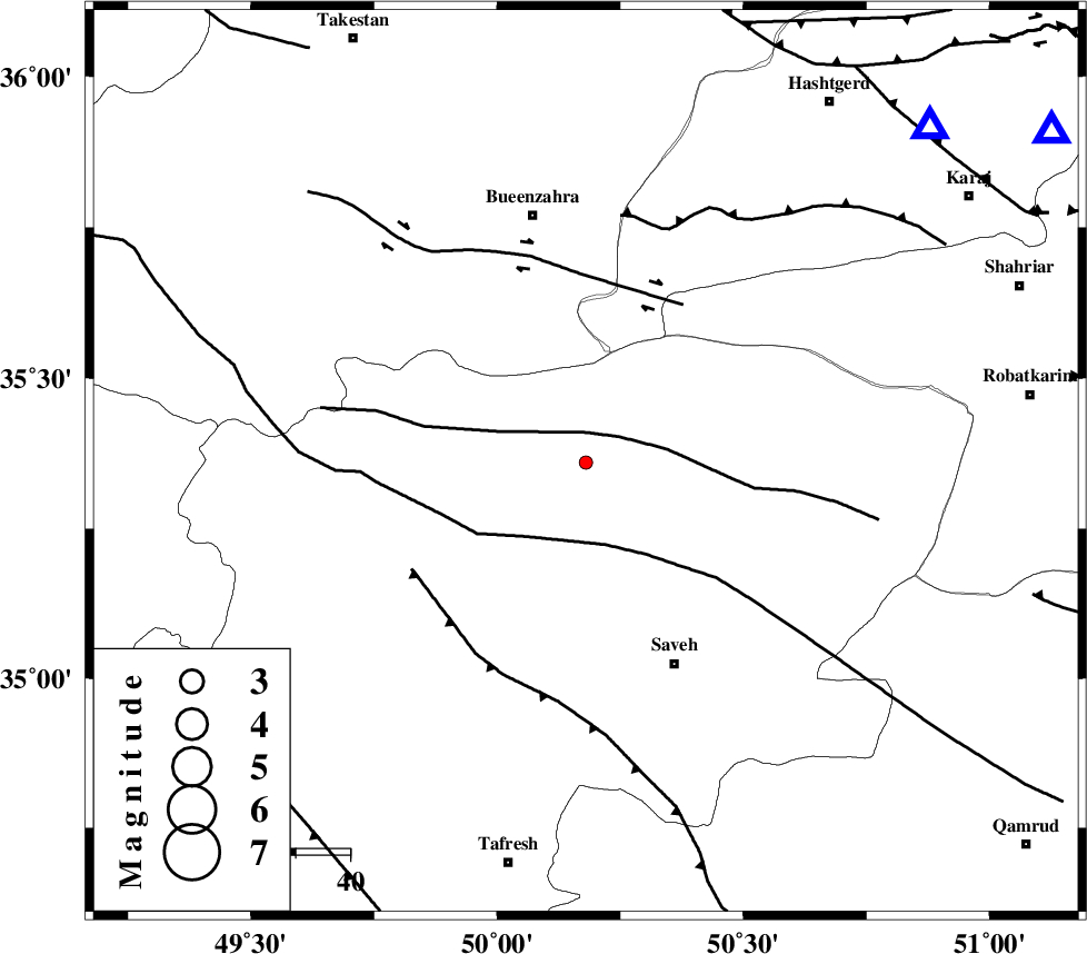
| Location | Lat:35.36 Lon: 50.18 |
| Region | Markazi Province, 41 km North-West of Saveh |
Nearest Cities |
|
| 15 km West of Khoshkrud, Markazi Province | |
| 20 km North East of Razegian, Markazi Province | |
| 31 km North West of Hakimabad, Markazi Province | |
| 32 km North West of Memunieh, Markazi Province | |
| 33 km East of Duzaj, Markazi Province | |
| Depth | 14 km |
| Agency | |
Faults within 150 km: |
|
| S_PARANDAK_F (Length: 116 km) , Distance to epicenter: 6 km | |
| KUSHK_E_NOSRAT_F (Length: 230 km) , Distance to epicenter: 16 km | |
| IPAK_F (Length: 80 km) , Distance to epicenter: 34 km | |
| Number of Phases | 5 |
| RMS | 0.1 |
| Number of Stations | 4 |
| Error in Latitude | >1.8 km |
| Error in Longitude | 2.6 km |
| Error in Depth | 5.5 km |
Download waveform in seisan format
to download seisan software Click here
to access information about IIEES stations Click here
Amplitude | ||||||||
| UID | Agency | Station | Component | Amplitude | Period | Arrival Time | Proccessing Time | Signal Clip |
| 91390 | IIEES | GHVR | E | 13.4 | 0.36 | 2014-01-06 11:14:28 | 2014-01-07 12:01:00 | n |
| 91391 | IIEES | GHVR | N | 17.5 | 0.44 | 2014-01-06 11:14:30 | 2014-01-07 12:01:00 | n |
| 91392 | IIEES | KHMZ | E | 6.1 | 0.4 | 2014-01-06 11:14:45 | 2014-01-07 12:01:00 | n |
Phase | ||||||||||||
| Agency | Station | Component | Phase Type | Phase Quality | First Motion | Observed Arrival Time | Time Residual | Loc. Flag | Input Weight | Distance | Azimuth | |
| IIEES | CHTH | Z | Pg | E | 2014-01-06 11:13:57 | -0.13 | y | 105 | 54 | |||
| IIEES | GHVR | Z | Pg | E | 2014-01-06 11:14:03 | 0.18 | y | 138 | 135 | |||
| IIEES | KHMZ | Z | Pg | E | 2014-01-06 11:14:09 | -0.16 | y | 181 | 186 | |||
| IIEES | ZNJK | Z | Pn | E | 2014-01-06 11:14:12 | 0.14 | y | 198 | 318 | |||
| IIEES | ZNJK | E | Sg | E | 2014-01-06 11:14:36 | -0.03 | y | 198 | 318 | |||