
Magnitude |
2.9 |
| Date & Time (UTC) | 2014-01-08 14:33:35.9 |
| Date & Time (Local) | 1392/10/18 18:03:35.9 |
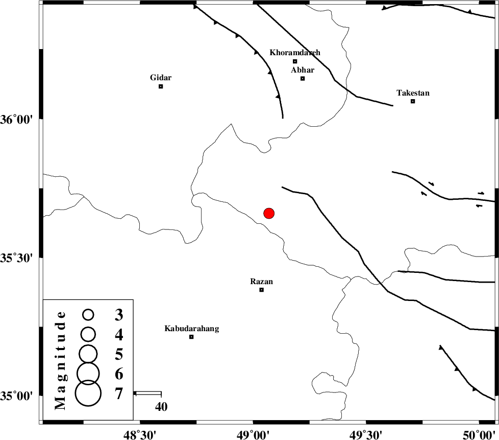
| Location | Lat:35.66 Lon: 49.07 |
| Region | Ghazvin Province, 31 km North of Razan |
Nearest Cities |
|
| 17 km North West of Avaj, Ghazvin Province | |
| 22 km West of Ab-e garm, Ghazvin Province | |
| 29 km North East of Khorandeh, Hamedan Province | |
| 31 km North of Razan, Hamedan Province | |
| 33 km North East of Damag, Hamedan Province | |
| Depth | 14 km |
| Agency | |
Faults within 150 km: |
|
| KUSHK_E_NOSRAT_F (Length: 230 km) , Distance to epicenter: 12 km | |
| SOLTANIYEH_F (Length: 119 km) , Distance to epicenter: 38 km | |
| IPAK_F (Length: 80 km) , Distance to epicenter: 52 km | |
| Number of Phases | 8 |
| RMS | 0.1 |
| Number of Stations | 7 |
| Error in Latitude | >1.1 km |
| Error in Longitude | 0.9 km |
| Error in Depth | 2.9 km |
Download waveform in seisan format
to download seisan software Click here
to access information about IIEES stations Click here
Amplitude | ||||||||
| UID | Agency | Station | Component | Amplitude | Period | Arrival Time | Proccessing Time | Signal Clip |
| 91401 | IIEES | THKV | E | 118.1 | 0.2 | 2014-01-08 14:34:27 | 2014-01-08 02:58:00 | n |
| 91402 | IIEES | SNGE | N | 117.1 | 0.48 | 2014-01-08 14:34:25 | 2014-01-08 02:58:00 | n |
| 91403 | IIEES | CHTH | N | 129.3 | 0.24 | 2014-01-08 14:34:30 | 2014-01-08 02:58:00 | n |
| 91404 | IIEES | DAMV | E | 83.2 | 0.68 | 2014-01-08 14:34:53 | 2014-01-08 02:58:00 | n |
Phase | ||||||||||||
| Agency | Station | Component | Phase Type | Phase Quality | First Motion | Observed Arrival Time | Time Residual | Loc. Flag | Input Weight | Distance | Azimuth | |
| IIEES | ZNJK | Z | Pg | E | 2014-01-08 14:33:55 | 0.05 | y | 118 | 343 | |||
| IIEES | ASAO | Z | Pg | E | 2014-01-08 14:34:01 | -0.04 | y | 151 | 144 | |||
| IIEES | ASAO | N | Sg | E | 2014-01-08 14:34:19 | 0.02 | y | 151 | 144 | |||
| IIEES | SNGE | Z | Pg | E | 2014-01-08 14:34:03 | 0.06 | y | 169 | 249 | |||
| IIEES | SNGE | N | Sg | E | 2014-01-08 14:34:24 | -0.07 | y | 169 | 249 | |||
| IIEES | CHTH | Z | Pn | E | 2014-01-08 14:34:06 | -0.14 | y | 188 | 81 | |||
| IIEES | CHTH | N | Sg | E | 2014-01-08 14:34:29 | -0.02 | y | 188 | 81 | |||
| IIEES | GHVR | Z | Pn | E | 2014-01-08 14:34:13 | 0.14 | y | 238 | 123 | |||