
Magnitude |
2.7 |
| Date & Time (UTC) | 2014-01-18 17:20:16.7 |
| Date & Time (Local) | 1392/10/28 20:50:16.7 |
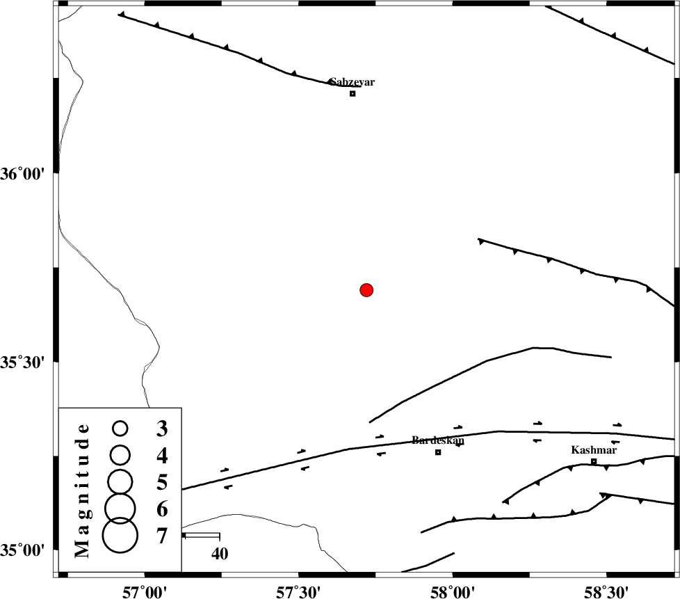
| Location | Lat:35.69 Lon: 57.72 |
| Region | Khorasan(center) Province, 58 km South of Sabzevar |
Nearest Cities |
|
| 14 km South of Tondak, Khorasan(center) Province | |
| 15 km South East of Bejdan, Khorasan(center) Province | |
| 30 km South of Sheshtamad, Khorasan(center) Province | |
| 38 km North West of Ghaleh meidan, Khorasan(center) Province | |
| 42 km North West of Kabudan, Khorasan(center) Province | |
| Depth | 14 km |
| Agency | |
Faults within 150 km: |
|
| BIJVARD_F (Length: 83 km) , Distance to epicenter: 35 km | |
| BALHAR_F (Length: 117 km) , Distance to epicenter: 36 km | |
| DORUNEH_F (Length: 713 km) , Distance to epicenter: 46 km | |
| Number of Phases | 4 |
| RMS | 0.1 |
| Number of Stations | 4 |
| Error in Latitude | >1.4 km |
| Error in Longitude | 6 km |
| Error in Depth | 5.5 km |
Download waveform in seisan format
to download seisan software Click here
to access information about IIEES stations Click here
Amplitude | ||||||||
| UID | Agency | Station | Component | Amplitude | Period | Arrival Time | Proccessing Time | Signal Clip |
| 91539 | IIEES | SHRO | E | 149.4 | 0.52 | 2014-01-18 17:21:06 | 2014-01-18 06:25:00 | n |
| 91540 | IIEES | TABS | N | 41.9 | 0.52 | 2014-01-18 17:21:24 | 2014-01-18 06:25:00 | n |
Phase | ||||||||||||
| Agency | Station | Component | Phase Type | Phase Quality | First Motion | Observed Arrival Time | Time Residual | Loc. Flag | Input Weight | Distance | Azimuth | |
| IIEES | BJRD | N | Pg | E | 2014-01-18 17:20:53 | -0.04 | y | 225 | 353 | |||
| IIEES | TABS | Z | Pn | E | 2014-01-18 17:20:53 | 0.13 | y | 233 | 194 | |||
| IIEES | TABS | N | Sg | E | 2014-01-18 17:21:22 | -0.08 | y | 233 | 194 | |||
| IIEES | SHRT | Z | Pn | E | 2014-01-18 17:21:05 | -0.02 | y | 327 | 133 | |||

 IIEES All Rights Reserved