
Magnitude |
3.1 |
| Date & Time (UTC) | 2014-01-26 07:31:23.8 |
| Date & Time (Local) | 1392/11/6 11:01:23.8 |
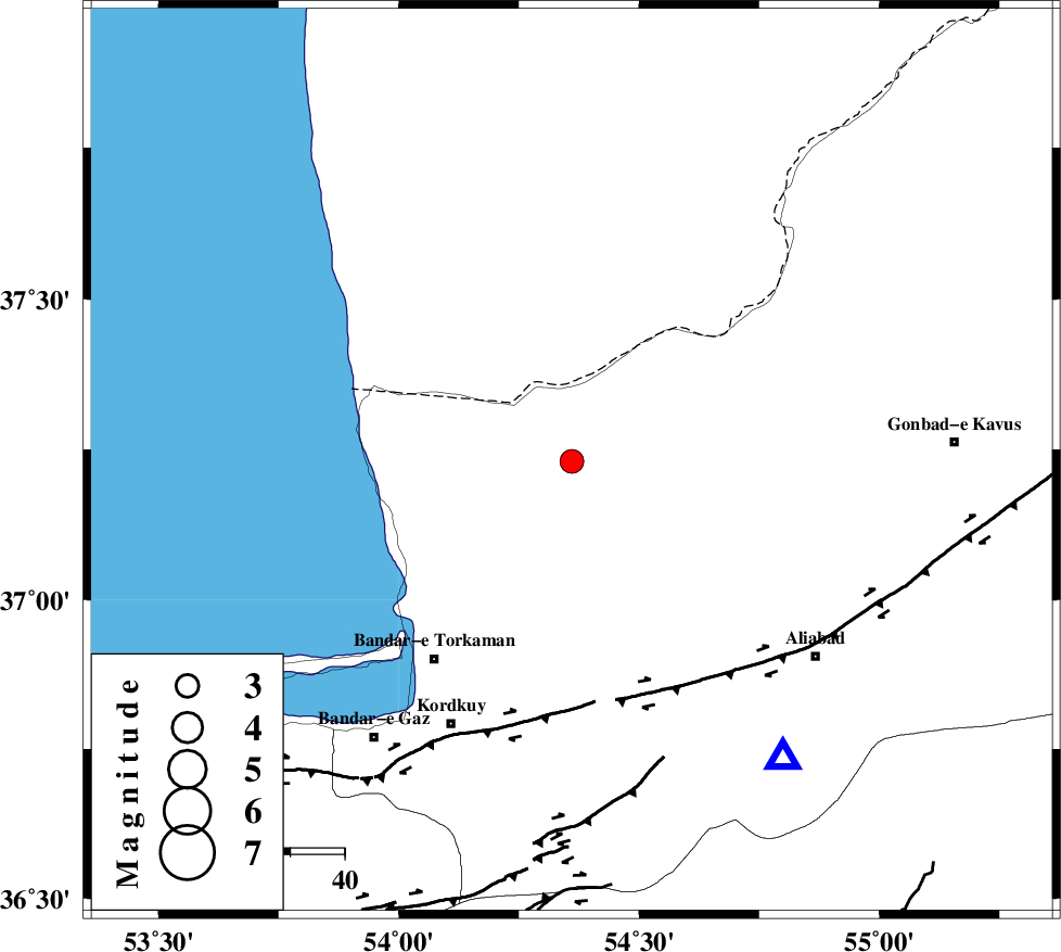
| Location | Lat:37.23 Lon: 54.36 |
| Region | Golestan Province, 25 km North of Aq Qaleh |
Nearest Cities |
|
| 26 km North of Aq Qaleh, Golestan Province | |
| 27 km North East of Banavar, Golestan Province | |
| 27 km North West of Qanqarmeh, Golestan Province | |
| 29 km North East of Gomishtappeh, Golestan Province | |
| 35 km North West of Nodeh malek, Golestan Province | |
| Depth | 15 km |
| Agency | |
Faults within 150 km: |
|
| KHAZAR_F (Length: 523 km) , Distance to epicenter: 44 km | |
| N_ALBORZ_F (Length: 360 km) , Distance to epicenter: 69 km | |
| SHAVAR_F (Length: 87 km) , Distance to epicenter: 74 km | |
| Number of Phases | 9 |
| RMS | 0.5 |
| Number of Stations | 9 |
| Error in Latitude | >7.9 km |
| Error in Longitude | 3.1 km |
| Error in Depth | 0 km |
Download waveform in seisan format
to download seisan software Click here
to access information about IIEES stations Click here
Amplitude | ||||||||
| UID | Agency | Station | Component | Amplitude | Period | Arrival Time | Proccessing Time | Signal Clip |
| 91602 | IIEES | THKV | E | 53.9 | 0.46 | 2014-01-26 07:33:04 | 2014-01-26 08:54:00 | n |
Phase | ||||||||||||
| Agency | Station | Component | Phase Type | Phase Quality | First Motion | Observed Arrival Time | Time Residual | Loc. Flag | Input Weight | Distance | Azimuth | |
| IIEES | SHRO | E | Pn | E | 2014-01-26 07:31:56 | -0.45 | y | 201 | 132 | |||
| IIEES | BJRD | Z | Pn | E | 2014-01-26 07:32:06 | 0.54 | y | 275 | 78 | |||
| IIEES | CHTH | Z | Pn | E | 2014-01-26 07:32:12 | 0.47 | y | 324 | 244 | |||
| IIEES | THKV | Z | Pn | E | 2014-01-26 07:32:13 | -0.53 | y | 343 | 246 | |||
| IIEES | GHVR | Z | Pn | E | 2014-01-26 07:32:23 | 0.41 | y | 414 | 224 | |||
| IIEES | TABS | Z | Pn | E | 2014-01-26 07:32:30 | 0.23 | y | 470 | 147 | |||
| IIEES | ASAO | Z | Pn | E | 2014-01-26 07:32:32 | 0.29 | y | 491 | 234 | |||
| IIEES | GRMI | Z | Pn | E | 2014-01-26 07:32:44 | -0.66 | y | 594 | 289 | |||
| IIEES | SHRT | Z | Pn | E | 2014-01-26 07:32:53 | -0.7 | y | 669 | 125 | |||