
Magnitude |
2.3 |
| Date & Time (UTC) | 2014-01-28 05:38:43.3 |
| Date & Time (Local) | 1392/11/8 09:08:43.3 |
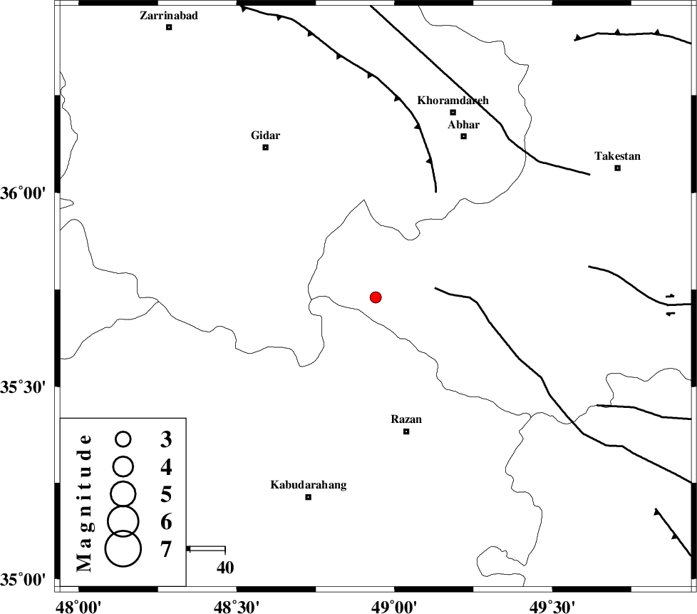
| Location | Lat:35.73 Lon: 48.94 |
| Region | Ghazvin Province, 39 km North-West of Razan |
Nearest Cities |
|
| 24 km North East of Kahla, Zanjan Province | |
| 27 km North East of Khorandeh, Hamedan Province | |
| 31 km North West of Avaj, Ghazvin Province | |
| 32 km West of Ab-e garm, Ghazvin Province | |
| 34 km North East of Damag, Hamedan Province | |
| Depth | 14 km |
| Agency | |
Faults within 150 km: |
|
| KUSHK_E_NOSRAT_F (Length: 230 km) , Distance to epicenter: 17 km | |
| SOLTANIYEH_F (Length: 119 km) , Distance to epicenter: 35 km | |
| ZANJAN_F (Length: 137 km) , Distance to epicenter: 59 km | |
| Number of Phases | 8 |
| RMS | 0.4 |
| Number of Stations | 6 |
| Error in Latitude | >3.5 km |
| Error in Longitude | 3.7 km |
| Error in Depth | 9.1 km |
Download waveform in seisan format
to download seisan software Click here
to access information about IIEES stations Click here
Amplitude | ||||||||
| UID | Agency | Station | Component | Amplitude | Period | Arrival Time | Proccessing Time | Signal Clip |
| 91619 | IIEES | SNGE | N | 57.7 | 0.43 | 2014-01-28 05:39:30 | 2014-01-28 11:09:00 | n |
| 91620 | IIEES | SNGE | E | 41.1 | 0.39 | 2014-01-28 05:39:31 | 2014-01-28 11:09:00 | n |
| 91621 | IIEES | THKV | E | 38.2 | 0.28 | 2014-01-28 05:39:35 | 2014-01-28 11:09:00 | n |
| 91622 | IIEES | CHTH | N | 29 | 0.32 | 2014-01-28 05:39:39 | 2014-01-28 11:09:00 | n |
Phase | ||||||||||||
| Agency | Station | Component | Phase Type | Phase Quality | First Motion | Observed Arrival Time | Time Residual | Loc. Flag | Input Weight | Distance | Azimuth | |
| IIEES | ZNJK | Z | Pg | E | 2014-01-28 05:39:01 | 0.16 | y | 107 | 348 | |||
| IIEES | SNGE | Z | Pg | E | 2014-01-28 05:39:09 | -0.17 | y | 160 | 245 | |||
| IIEES | SNGE | N | Sg | E | 2014-01-28 05:39:29 | -0.01 | y | 160 | 245 | |||
| IIEES | ASAO | Z | Pg | E | 2014-01-28 05:39:10 | 0.11 | y | 164 | 142 | |||
| IIEES | ASAO | N | Sg | E | 2014-01-28 05:39:30 | -0.18 | y | 164 | 142 | |||
| IIEES | THKV | Z | Pn | E | 2014-01-28 05:39:12 | -0.54 | y | 177 | 83 | |||
| IIEES | CHTH | Z | Pn | E | 2014-01-28 05:39:15 | -0.16 | y | 199 | 84 | |||
| IIEES | GHVR | Z | Pn | E | 2014-01-28 05:39:23 | 0.81 | y | 252 | 123 | |||