
Magnitude |
2.8 |
| Date & Time (UTC) | 2014-01-30 13:36:50.5 |
| Date & Time (Local) | 1392/11/10 17:06:50.5 |
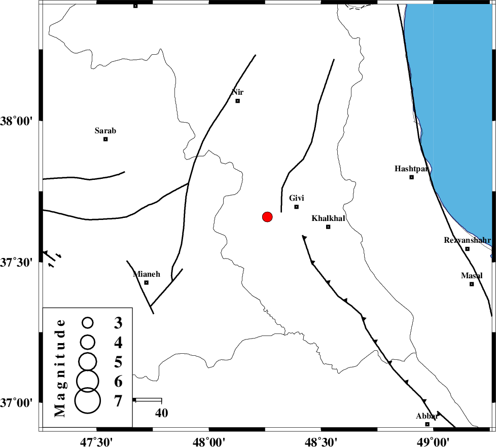
| Location | Lat:37.66 Lon: 48.26 |
| Region | Ardebil Province, 12 km West of Givi |
Nearest Cities |
|
| 5 km of Ganjgah, Ardebil Province | |
| 6 km North of Firuz Abad, Ardebil Province | |
| 12 km West of Givi, Ardebil Province | |
| 15 km North West of Gazaz, Ardebil Province | |
| 24 km North West of Khalkhal, Ardebil Province | |
| Depth | 14 km |
| Agency | |
Faults within 150 km: |
|
| SANGAVAR_F (Length: 61 km) , Distance to epicenter: 6 km | |
| MASULEL_F (Length: 90 km) , Distance to epicenter: 16 km | |
| BOZQUSH (Length: 70 km) , Distance to epicenter: 34 km | |
| Number of Phases | 5 |
| RMS | 0 |
| Number of Stations | 4 |
| Error in Latitude | >0.8 km |
| Error in Longitude | 4.2 km |
| Error in Depth | 5.7 km |
Download waveform in seisan format
to download seisan software Click here
to access information about IIEES stations Click here
Amplitude | ||||||||
| UID | Agency | Station | Component | Amplitude | Period | Arrival Time | Proccessing Time | Signal Clip |
| 91645 | IIEES | GRMI | N | 152.3 | 0.6 | 2014-01-30 13:37:32 | 2014-01-30 02:18:00 | n |
| 91646 | IIEES | GRMI | E | 247.4 | 0.29 | 2014-01-30 13:37:32 | 2014-01-30 02:18:00 | n |
Phase | ||||||||||||
| Agency | Station | Component | Phase Type | Phase Quality | First Motion | Observed Arrival Time | Time Residual | Loc. Flag | Input Weight | Distance | Azimuth | |
| IIEES | ZNJK | Z | Pg | E | 2014-01-30 13:37:10 | -0.07 | y | 116 | 161 | |||
| IIEES | GRMI | Z | Pg | E | 2014-01-30 13:37:12 | 0.01 | y | 131 | 346 | |||
| IIEES | GRMI | E | Sg | E | 2014-01-30 13:37:28 | -0.01 | y | 131 | 346 | |||
| IIEES | SNGE | N | Sg | E | 2014-01-30 13:38:14 | 0.02 | y | 296 | 196 | |||
| IIEES | CHTH | Z | Pn | E | 2014-01-30 13:37:38 | 0.05 | y | 322 | 126 | |||