
Magnitude |
2.9 |
| Date & Time (UTC) | 2014-02-07 04:51:31.2 |
| Date & Time (Local) | 1392/11/18 08:21:31.2 |
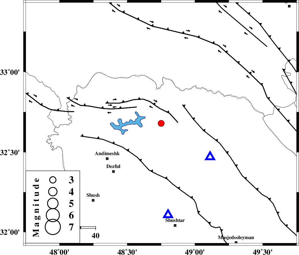
| Location | Lat:32.68 Lon: 48.75 |
| Region | Khoozestan Province, 45 km North-East of Andimeshk |
Nearest Cities |
|
| 14 km South of Shuy, Khoozestan Province | |
| 21 km North of Sardasht, Khoozestan Province | |
| 33 km North of Mahur berenji, Khoozestan Province | |
| 41 km East of Sorkhakan, Khoozestan Province | |
| 44 km South West of Bargsar, Lorestan Province | |
| Depth | 14 km |
| Agency | |
Faults within 150 km: |
|
| BALARUD_F_Z2 (Length: 58 km) , Distance to epicenter: 9 km | |
| MFF2 (Length: 205 km) , Distance to epicenter: 20 km | |
| BALARUD_F_Z3 (Length: 53 km) , Distance to epicenter: 20 km | |
| Number of Phases | 5 |
| RMS | 0.1 |
| Number of Stations | 5 |
| Error in Latitude | >2.5 km |
| Error in Longitude | 4.6 km |
| Error in Depth | 5.5 km |
Download waveform in seisan format
to download seisan software Click here
to access information about IIEES stations Click here
Amplitude | ||||||||
| UID | Agency | Station | Component | Amplitude | Period | Arrival Time | Proccessing Time | Signal Clip |
| 91744 | IIEES | SHGR | E | 656.5 | 0.48 | 2014-02-07 04:51:55 | 2014-02-07 05:18:00 | n |
Phase | ||||||||||||
| Agency | Station | Component | Phase Type | Phase Quality | First Motion | Observed Arrival Time | Time Residual | Loc. Flag | Input Weight | Distance | Azimuth | |
| IIEES | SHGR | Z | Pg | E | 2014-02-07 04:51:42 | -0.02 | y | 63.9 | 175 | |||
| IIEES | KHMZ | Z | Pg | E | 2014-02-07 04:51:58 | -0.2 | y | 163 | 44 | |||
| IIEES | ASAO | Z | Pn | E | 2014-02-07 04:52:08 | 0.1 | y | 238 | 29 | |||
| IIEES | SNGE | Z | Pn | E | 2014-02-07 04:52:15 | -0.03 | y | 297 | 335 | |||
| IIEES | GHVR | Z | Pn | E | 2014-02-07 04:52:17 | 0.17 | y | 306 | 49 | |||