
Magnitude |
4.1 |
| Date & Time (UTC) | 2014-02-27 06:05:13.3 |
| Date & Time (Local) | 1392/12/8 09:35:13.3 |
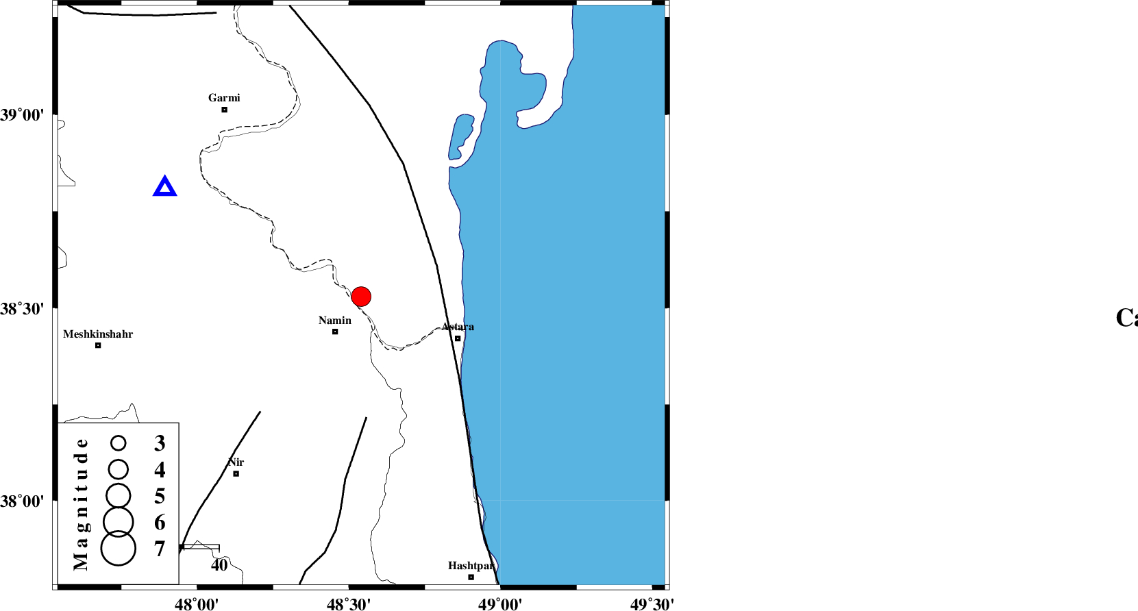
| Location | Lat:38.53 Lon: 48.54 |
| Region | Azerbaijan, 12 km Namin |
Nearest Cities |
|
| 8 km North of Anbaran, Ardebil Province | |
| 13 km North of Namin, Ardebil Province | |
| 13 km North East of Khaneh zeinian, Ardebil Province | |
| 17 km East of Lurun, Ardebil Province | |
| 18 km North of Nanehkaran, Ardebil Province | |
| Depth | 22 km |
| Agency | |
Faults within 150 km: |
|
| TALESH_F (Length: 258 km) , Distance to epicenter: 23 km | |
| SANGAVAR_F (Length: 61 km) , Distance to epicenter: 35 km | |
| BOZQUSH (Length: 70 km) , Distance to epicenter: 44 km | |
| Number of Phases | 10 |
| RMS | 0.2 |
| Number of Stations | 8 |
| Error in Latitude | >2.5 km |
| Error in Longitude | 4 km |
| Error in Depth | 3.7 km |
Download waveform in seisan format
to download seisan software Click here
to access information about IIEES stations Click here
Amplitude | ||||||||
| UID | Agency | Station | Component | Amplitude | Period | Arrival Time | Proccessing Time | Signal Clip |
| 91886 | IIEES | THKV | E | 437.1 | 0.39 | 2014-02-27 06:06:41 | 2014-02-27 06:39:00 | n |
Phase | ||||||||||||
| Agency | Station | Component | Phase Type | Phase Quality | First Motion | Observed Arrival Time | Time Residual | Loc. Flag | Input Weight | Distance | Azimuth | |
| IIEES | GRMI | Z | Pg | E | 2014-02-27 06:05:24 | 0.17 | y | 64.4 | 300 | |||
| IIEES | GRMI | E | Sg | E | 2014-02-27 06:05:33 | -0.03 | y | 64.4 | 300 | |||
| IIEES | ZNJK | Z | Pg | E | 2014-02-27 06:05:46 | -0.08 | y | 206 | 176 | |||
| IIEES | ZNJK | E | Sg | E | 2014-02-27 06:06:10 | -0.06 | y | 206 | 176 | |||
| IIEES | MAKU | Z | Pn | E | 2014-02-27 06:06:03 | -0.22 | y | 347 | 287 | |||
| IIEES | MAKU | N | Sg | E | 2014-02-27 06:06:48 | -0.02 | y | 347 | 287 | |||
| IIEES | CHTH | Z | Pn | E | 2014-02-27 06:06:06 | -0.14 | y | 370 | 141 | |||
| IIEES | SNGE | Z | Pn | E | 2014-02-27 06:06:09 | 0.21 | y | 395 | 196 | |||
| IIEES | ASAO | Z | Pn | E | 2014-02-27 06:06:18 | 0.32 | y | 461 | 163 | |||
| IIEES | GHVR | Z | Pn | E | 2014-02-27 06:06:23 | -0.1 | y | 510 | 151 | |||