
Magnitude |
2 |
| Date & Time (UTC) | 2014-03-05 02:31:57.3 |
| Date & Time (Local) | 1392/12/14 06:01:57.3 |
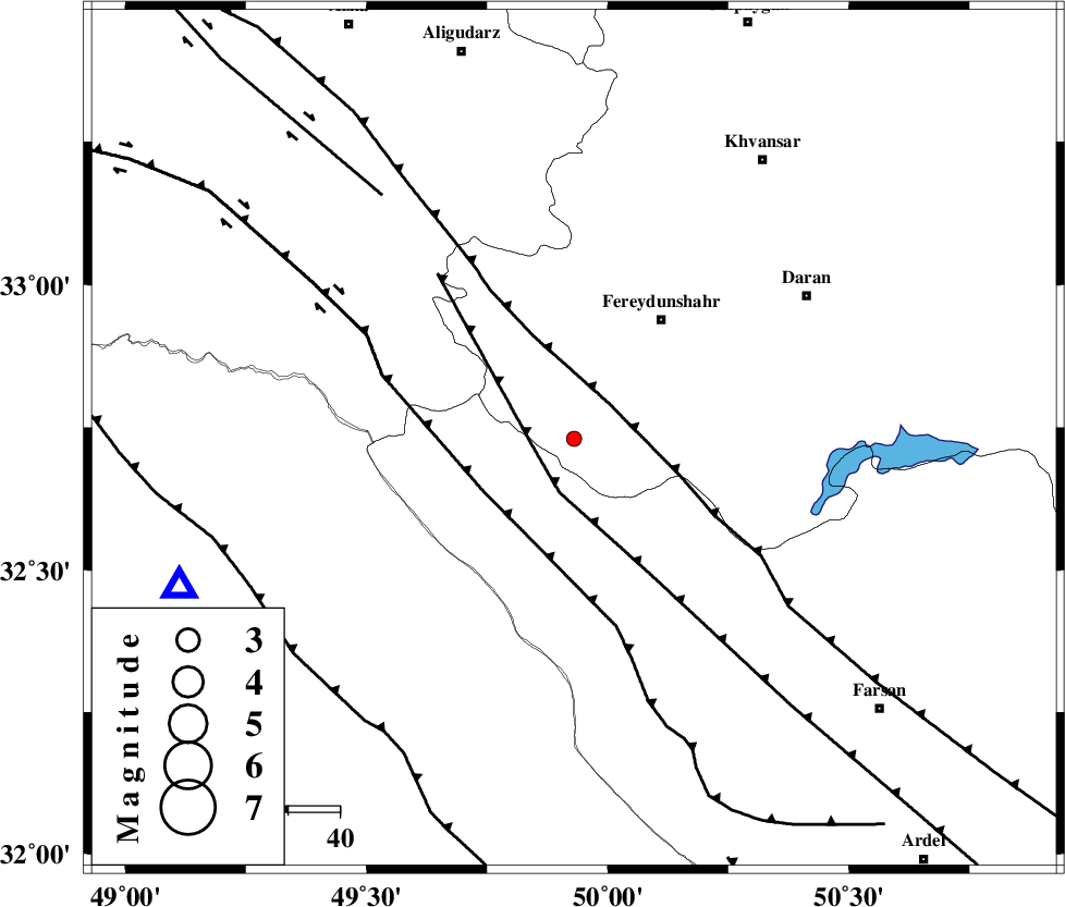
| Location | Lat:32.73 Lon: 49.93 |
| Region | Esfahan Province, 29 km South-West of Fereydunshahr |
Nearest Cities |
|
| 8 km North of Durak, Chaharmahal Bakhtiari Province | |
| 15 km South of Masir, Esfahan Province | |
| 21 km South West of Sibak, Esfahan Province | |
| 28 km West of Ghale? sorkh, Esfahan Province | |
| 29 km South West of Fereydunshahr, Esfahan Province | |
| Depth | 34 km |
| Agency | |
Faults within 150 km: |
|
| ARDAL_F (Length: 170 km) , Distance to epicenter: 8 km | |
| MAIN_ZAGROS_R_F (Length: 1106 km) , Distance to epicenter: 10 km | |
| ZARDKUH_F (Length: 139 km) , Distance to epicenter: 20 km | |
| Number of Phases | 5 |
| RMS | 0 |
| Number of Stations | 4 |
| Error in Latitude | >5.1 km |
| Error in Longitude | 5.7 km |
| Error in Depth | 7.7 km |
Download waveform in seisan format
to download seisan software Click here
to access information about IIEES stations Click here
Amplitude | ||||||||
| UID | Agency | Station | Component | Amplitude | Period | Arrival Time | Proccessing Time | Signal Clip |
| 91924 | IIEES | KHMZ | E | 38.3 | 0.32 | 2014-03-05 02:32:31 | 2014-03-05 03:32:00 | n |
| 91925 | IIEES | GHVR | N | 10.2 | 0.56 | 2014-03-05 02:33:12 | 2014-03-05 03:32:00 | n |
Phase | ||||||||||||
| Agency | Station | Component | Phase Type | Phase Quality | First Motion | Observed Arrival Time | Time Residual | Loc. Flag | Input Weight | Distance | Azimuth | |
| IIEES | KHMZ | Z | Pg | E | 2014-03-05 02:32:16 | 0.01 | y | 112 | 2 | |||
| IIEES | KHMZ | E | Sg | E | 2014-03-05 02:32:30 | 0 | y | 112 | 2 | |||
| IIEES | ASAO | Z | Pg | E | 2014-03-05 02:32:30 | -0.02 | y | 202 | 3 | |||
| IIEES | GHVR | Z | Pg | E | 2014-03-05 02:32:34 | 0 | y | 230 | 32 | |||
| IIEES | SNGE | Z | Pn | E | 2014-03-05 02:32:47 | 0 | y | 355 | 318 | |||