
Magnitude |
4.1 |
| Date & Time (UTC) | 2014-03-15 02:20:53.7 |
| Date & Time (Local) | 1392/12/24 05:50:53.7 |
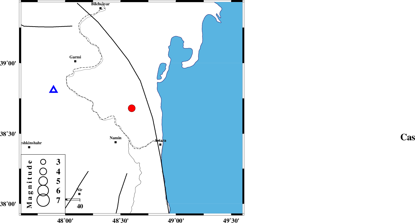
| Location | Lat:38.68 Lon: 48.6 |
| Region | Azerbaijan, 30 km North-East of Namin |
Nearest Cities |
|
| 24 km North East of Anbaran, Ardebil Province | |
| 25 km North East of Lurun, Ardebil Province | |
| 29 km North East of Khaneh zeinian, Ardebil Province | |
| 30 km North East of Namin, Ardebil Province | |
| 34 km North of Kiladeh, Gilan Province | |
| Depth | 14 km |
| Agency | |
Faults within 150 km: |
|
| TALESH_F (Length: 258 km) , Distance to epicenter: 18 km | |
| SANGAVAR_F (Length: 61 km) , Distance to epicenter: 52 km | |
| BOZQUSH (Length: 70 km) , Distance to epicenter: 60 km | |
| Number of Phases | 8 |
| RMS | 0.1 |
| Number of Stations | 6 |
| Error in Latitude | >2.6 km |
| Error in Longitude | 4.3 km |
| Error in Depth | 5.1 km |
Download waveform in seisan format
to download seisan software Click here
to access information about IIEES stations Click here
Amplitude | ||||||||
| UID | Agency | Station | Component | Amplitude | Period | Arrival Time | Proccessing Time | Signal Clip |
| 92000 | IIEES | GRMI | E | 12372 | 0.36 | 2014-03-15 02:21:13 | 2014-03-15 02:51:00 | n |
Phase | ||||||||||||
| Agency | Station | Component | Phase Type | Phase Quality | First Motion | Observed Arrival Time | Time Residual | Loc. Flag | Input Weight | Distance | Azimuth | |
| IIEES | GRMI | Z | Pg | E | 2014-03-15 02:21:04 | -0.07 | y | 63.1 | 283 | |||
| IIEES | GRMI | N | Sg | E | 2014-03-15 02:21:13 | 0.05 | y | 63.1 | 283 | |||
| IIEES | ZNJK | Z | Pn | E | 2014-03-15 02:21:29 | -0.01 | y | 223 | 178 | |||
| IIEES | ZNJK | E | Sg | E | 2014-03-15 02:21:57 | -0.01 | y | 223 | 178 | |||
| IIEES | CHTH | Z | Pn | E | 2014-03-15 02:21:48 | -0.2 | y | 381 | 143 | |||
| IIEES | SNGE | Z | Pn | E | 2014-03-15 02:21:52 | -0.04 | y | 414 | 196 | |||
| IIEES | ASAO | Z | Pn | E | 2014-03-15 02:22:00 | 0.23 | y | 476 | 164 | |||
| IIEES | GHVR | Z | Pn | E | 2014-03-15 02:22:06 | 0.09 | y | 523 | 152 | |||