
Magnitude |
2.8 |
| Date & Time (UTC) | 2014-04-07 02:35:10.9 |
| Date & Time (Local) | 1393/1/18 07:05:10.9 |
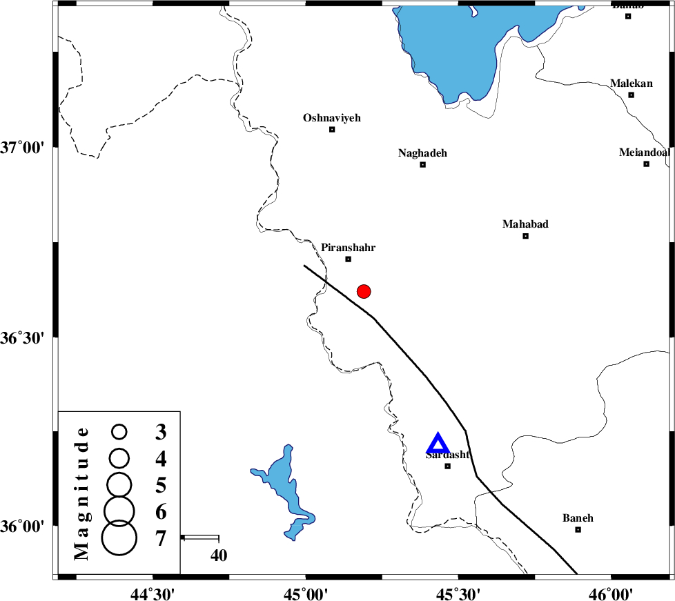
| Location | Lat:36.62 Lon: 45.19 |
| Region | Azarbaijan Gharbi Province, 11 km Piranshahr |
Nearest Cities |
|
| 1 km North of Chiyaneh, Azarbaijan Gharbi Province | |
| 9 km North of Kavir, Azarbaijan Gharbi Province | |
| 10 km of Piranshahr, Azarbaijan Gharbi Province | |
| 21 km South of Kardkeshaneh, Azarbaijan Gharbi Province | |
| 22 km South of Silveh, Azarbaijan Gharbi Province | |
| Depth | 14 km |
| Agency | |
Faults within 150 km: |
|
| PIRANSHAHR_F (Length: 253 km) , Distance to epicenter: 8 km | |
| HZF4 (Length: 492 km) , Distance to epicenter: 123 km | |
| Number of Phases | 6 |
| RMS | 0.1 |
| Number of Stations | 3 |
| Error in Latitude | >1.3 km |
| Error in Longitude | 7 km |
| Error in Depth | 7.7 km |
Download waveform in seisan format
to download seisan software Click here
to access information about IIEES stations Click here
Amplitude | ||||||||
| UID | Agency | Station | Component | Amplitude | Period | Arrival Time | Proccessing Time | Signal Clip |
| 92173 | IIEES | SNGE | N | 55.3 | 0.68 | 2014-04-07 02:36:34 | 2014-04-07 04:03:00 | n |
Phase | ||||||||||||
| Agency | Station | Component | Phase Type | Phase Quality | First Motion | Observed Arrival Time | Time Residual | Loc. Flag | Input Weight | Distance | Azimuth | |
| IIEES | SNGE | Z | Pn | E | 2014-04-07 02:35:50 | -0.02 | y | 258 | 130 | |||
| IIEES | SNGE | N | Sg | E | 2014-04-07 02:36:23 | -0.09 | y | 258 | 130 | |||
| IIEES | ZNJK | Z | Pn | E | 2014-04-07 02:35:57 | 0.06 | y | 312 | 88 | |||
| IIEES | ZNJK | N | Sg | E | 2014-04-07 02:36:38 | 0.12 | y | 312 | 88 | |||
| IIEES | GRMI | Z | Pn | E | 2014-04-07 02:36:01 | 0.07 | y | 340 | 44 | |||
| IIEES | GRMI | E | Sg | E | 2014-04-07 02:36:46 | -0.14 | y | 340 | 44 | |||