
Magnitude |
2.7 |
| Date & Time (UTC) | 2014-04-14 02:28:47.7 |
| Date & Time (Local) | 1393/1/25 06:58:47.7 |
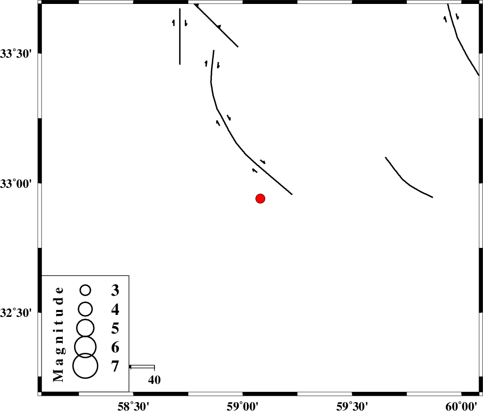
| Location | Lat:32.94 Lon: 59.08 |
| Region | Khorasan(south) Province, 15 km West of Birjand |
Nearest Cities |
|
| 15 km North West of Birjand, Khorasan(south) Province | |
| 22 km West of Hajiabad, Khorasan(south) Province | |
| 26 km North West of Gol, Khorasan(south) Province | |
| 28 km North East of Khusef, Khorasan(south) Province | |
| 30 km South of Konder, Khorasan(south) Province | |
| Depth | 14 km |
| Agency | |
Faults within 150 km: |
|
| MOHAMMADABAD_F (Length: 71 km) , Distance to epicenter: 14 km | |
| NOZAD_F (Length: 27 km) , Distance to epicenter: 56 km | |
| FERDOWS_F (Length: 101 km) , Distance to epicenter: 66 km | |
| Number of Phases | 4 |
| RMS | 0.1 |
| Number of Stations | 4 |
| Error in Latitude | >2 km |
| Error in Longitude | 1.8 km |
| Error in Depth | 4.9 km |
Download waveform in seisan format
to download seisan software Click here
to access information about IIEES stations Click here
Amplitude | ||||||||
| UID | Agency | Station | Component | Amplitude | Period | Arrival Time | Proccessing Time | Signal Clip |
| 92214 | IIEES | KRBR | N | 14.2 | 0.44 | 2014-04-14 02:30:48 | 2014-04-14 03:54:00 | n |
| 92215 | IIEES | KRBR | E | 11.8 | 0.44 | 2014-04-14 02:30:49 | 2014-04-14 03:54:00 | n |
Phase | ||||||||||||
| Agency | Station | Component | Phase Type | Phase Quality | First Motion | Observed Arrival Time | Time Residual | Loc. Flag | Input Weight | Distance | Azimuth | |
| IIEES | BSRN | Z | Pg | E | 2014-04-14 02:29:06 | -0.03 | y | 109 | 177 | |||
| IIEES | SHRT | Z | Pg | E | 2014-04-14 02:29:10 | -0.03 | y | 137 | 55 | |||
| IIEES | TABS | Z | Pn | E | 2014-04-14 02:29:20 | 0.16 | y | 198 | 294 | |||
| IIEES | TABS | N | Sg | E | 2014-04-14 02:29:44 | -0.1 | y | 198 | 294 | |||

 IIEES All Rights Reserved