
Magnitude |
4.1 |
| Date & Time (UTC) | 2014-04-16 01:14:07.4 |
| Date & Time (Local) | 1393/1/27 05:44:07.4 |
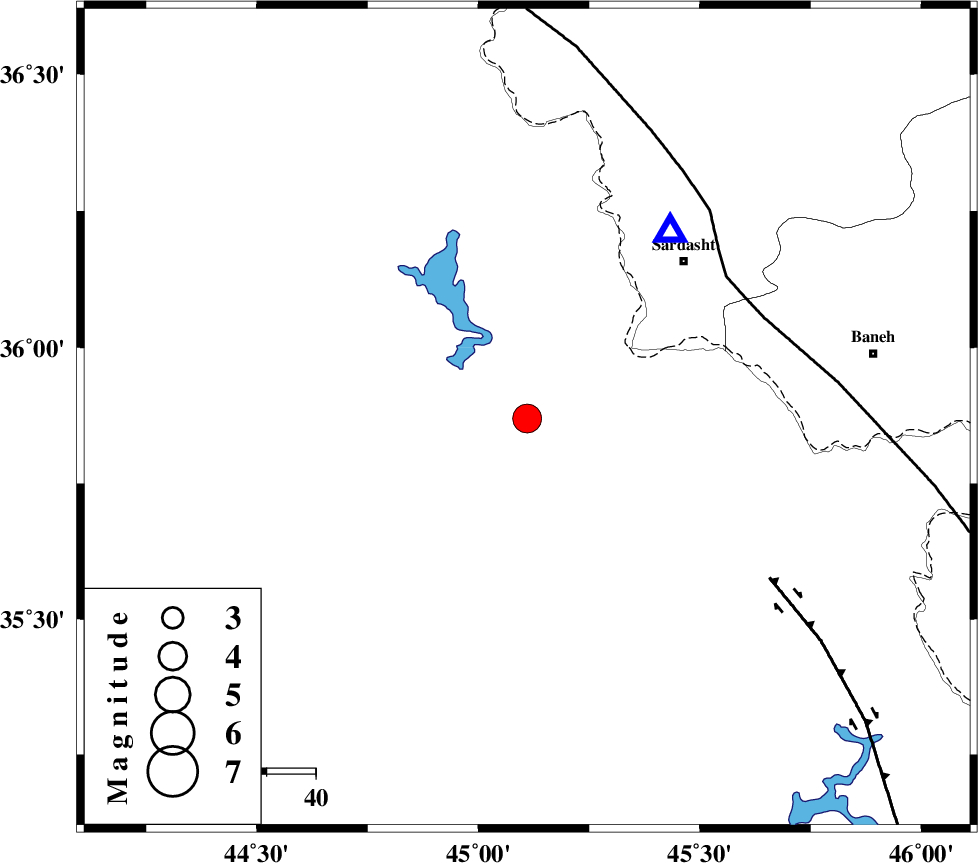
| Location | Lat:35.87 Lon: 45.11 |
| Region | Iraq, 45 km North-West of Sulaymaniyah |
Nearest Cities |
|
| 42 km South West of Bivaran-e sofla, Azarbaijan Gharbi Province | |
| 45 km South West of Sardasht, Azarbaijan Gharbi Province | |
| 45 km North West of Sulaymaniyah, Iraq Province | |
| 50 km South West of Bersiv, Azarbaijan Gharbi Province | |
| 54 km South West of Bolhasan, Kurdistan Province | |
| Depth | 14 km |
| Agency | |
Faults within 150 km: |
|
| PIRANSHAHR_F (Length: 253 km) , Distance to epicenter: 50 km | |
| HZF4 (Length: 492 km) , Distance to epicenter: 59 km | |
| MFF8 (Length: 48 km) , Distance to epicenter: 138 km | |
| Number of Phases | 7 |
| RMS | 0.2 |
| Number of Stations | 5 |
| Error in Latitude | >4 km |
| Error in Longitude | 8.1 km |
| Error in Depth | 8.9 km |
Download waveform in seisan format
to download seisan software Click here
to access information about IIEES stations Click here
Amplitude | ||||||||
| UID | Agency | Station | Component | Amplitude | Period | Arrival Time | Proccessing Time | Signal Clip |
| 92233 | IIEES | SNGE | N | 1383.9 | 0.64 | 2014-04-16 01:15:15 | 2014-04-16 02:37:00 | n |
| 92234 | IIEES | SHGR | N | 121.8 | 0.52 | 2014-04-16 01:16:23 | 2014-04-16 02:37:00 | n |
Phase | ||||||||||||
| Agency | Station | Component | Phase Type | Phase Quality | First Motion | Observed Arrival Time | Time Residual | Loc. Flag | Input Weight | Distance | Azimuth | |
| IIEES | SNGE | Z | Pg | E | 2014-04-16 01:14:43 | 0.04 | y | 220 | 112 | |||
| IIEES | SNGE | N | Sg | E | 2014-04-16 01:15:10 | 0.15 | y | 220 | 112 | |||
| IIEES | ZNJK | Z | Pn | E | 2014-04-16 01:14:57 | 0.32 | y | 333 | 73 | |||
| IIEES | ZNJK | N | Sg | E | 2014-04-16 01:15:40 | -0.25 | y | 333 | 73 | |||
| IIEES | ASAO | Z | Pn | E | 2014-04-16 01:15:13 | 0.04 | y | 471 | 107 | |||
| IIEES | KHMZ | Z | Pn | E | 2014-04-16 01:15:17 | -0.05 | y | 503 | 117 | |||
| IIEES | SHGR | Z | Pn | E | 2014-04-16 01:15:21 | -0.41 | y | 538 | 140 | |||