
Magnitude |
5 |
| Date & Time (UTC) | 2014-04-16 23:31:37.3 |
| Date & Time (Local) | 1393/1/28 04:01:37.3 |
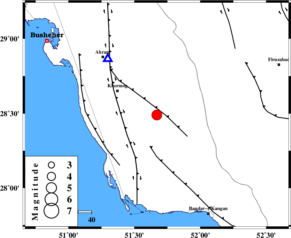
| Location | Lat:28.49 Lon: 51.67 |
| Region | Bushehr Province, 34 km South-East of Khormog |
Nearest Cities |
|
| 14 km North of Shanbeh, Bushehr Province | |
| 20 km North East of Baduleh, Bushehr Province | |
| 23 km North East of Kaki, Bushehr Province | |
| 31 km East of Buheyri, Bushehr Province | |
| 34 km South East of Khormog, Bushehr Province | |
| Depth | 11 km |
| Agency | |
Faults within 150 km: |
|
| MFF5 (Length: 74 km) , Distance to epicenter: 7 km | |
| MFF3 (Length: 292 km) , Distance to epicenter: 24 km | |
| BORAZJAN_F (Length: 168 km) , Distance to epicenter: 27 km | |
| Number of Phases | 8 |
| RMS | 0.2 |
| Number of Stations | 7 |
| Error in Latitude | >9.5 km |
| Error in Longitude | 8.1 km |
| Error in Depth | 11.3 km |
Download waveform in seisan format
to download seisan software Click here
to access information about IIEES stations Click here
Amplitude | ||||||||
| UID | Agency | Station | Component | Amplitude | Period | Arrival Time | Proccessing Time | Signal Clip |
| 92238 | IIEES | ASAO | N | 330 | 0.52 | 2014-04-16 23:34:28 | 2014-04-17 01:12:00 | n |
| 92239 | IIEES | ASAO | E | 320.1 | 0.64 | 2014-04-16 23:34:44 | 2014-04-17 01:12:00 | n |
| 92240 | IIEES | DAMV | E | 402.3 | 0.52 | 2014-04-16 23:34:48 | 2014-04-17 01:12:00 | n |
Phase | ||||||||||||
| Agency | Station | Component | Phase Type | Phase Quality | First Motion | Observed Arrival Time | Time Residual | Loc. Flag | Input Weight | Distance | Azimuth | |
| IIEES | KRBR | Z | Pn | E | 2014-04-16 23:32:50 | 0.25 | y | 522 | 70 | |||
| IIEES | KHMZ | Z | Pn | E | 2014-04-16 23:33:00 | 0.05 | y | 604 | 345 | |||
| IIEES | KHMZ | E | S | E | 2014-04-16 23:34:01 | 0 | y | 604 | 345 | |||
| IIEES | ASAO | Z | Pn | E | 2014-04-16 23:33:11 | 0.11 | y | 689 | 347 | |||
| IIEES | TABS | Z | Pn | E | 2014-04-16 23:33:21 | -0.2 | y | 773 | 41 | |||
| IIEES | DAMV | Z | Pn | E | 2014-04-16 23:33:23 | -0.39 | y | 792 | 2 | |||
| IIEES | CHBR | Z | Pn | E | 2014-04-16 23:33:40 | -0.28 | y | 931 | 108 | |||
| IIEES | ZNJK | Z | Pn | E | 2014-04-16 23:33:43 | 0.19 | y | 949 | 344 | |||