
Magnitude |
2.6 |
| Date & Time (UTC) | 2014-04-18 04:13:03.1 |
| Date & Time (Local) | 1393/1/29 08:43:03.1 |
| Location | Lat:38.6 Lon: 44.82 |
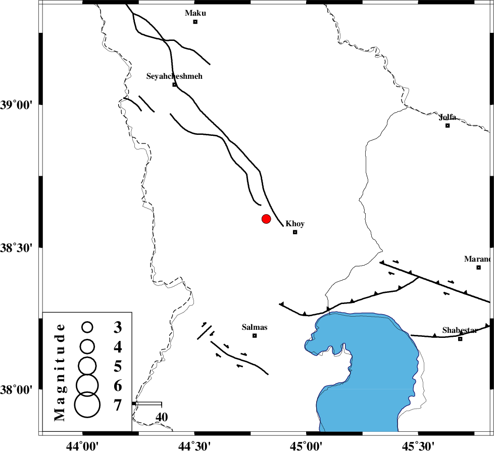
| Region | Azarbaijan Gharbi Province, 12 km West of Khoy |
Nearest Cities |
|
| 6 km North of Beyk sofla, Azarbaijan Gharbi Province | |
| 12 km North West of Khoy, Azarbaijan Gharbi Province | |
| 13 km West of Dizaj, Azarbaijan Gharbi Province | |
| 18 km North West of Saeedabad, Azarbaijan Gharbi Province | |
| 19 km North West of Quruq, Azarbaijan Gharbi Province | |
| Depth | 14 km |
| Agency | |
Faults within 150 km: |
|
| KHOY (Length: 100 km) , Distance to epicenter: 6 km | |
| N_TABRIZ_F3 (Length: 66 km) , Distance to epicenter: 34 km | |
| SALMAS (Length: 20 km) , Distance to epicenter: 47 km | |
| Number of Phases | 4 |
| RMS | 0.1 |
| Number of Stations | 3 |
| Error in Latitude | >4 km |
| Error in Longitude | 2.9 km |
| Error in Depth | 6.9 km |
Download waveform in seisan format
to download seisan software Click here
to access information about IIEES stations Click here
Amplitude | ||||||||
| UID | Agency | Station | Component | Amplitude | Period | Arrival Time | Proccessing Time | Signal Clip |
| 92242 | IIEES | MAKU | E | 262.1 | 0.52 | 2014-04-18 04:13:37 | 2014-04-18 05:44:00 | n |
| 92243 | IIEES | GRMI | N | 25.4 | 0.4 | 2014-04-18 04:14:21 | 2014-04-18 05:44:00 | n |
| 92244 | IIEES | SNGE | N | 7.5 | 0.64 | 2014-04-18 04:15:25 | 2014-04-18 05:44:00 | n |
Phase | ||||||||||||
| Agency | Station | Component | Phase Type | Phase Quality | First Motion | Observed Arrival Time | Time Residual | Loc. Flag | Input Weight | Distance | Azimuth | |
| IIEES | MAKU | Z | Pg | E | 2014-04-18 04:13:17 | -0.03 | y | 84.4 | 352 | |||
| IIEES | GRMI | Z | Pn | E | 2014-04-18 04:13:44 | 0.11 | y | 268 | 84 | |||
| IIEES | GRMI | N | Sg | E | 2014-04-18 04:14:18 | -0.04 | y | 268 | 84 | |||
| IIEES | SNGE | Z | Pn | E | 2014-04-18 04:14:06 | -0.05 | y | 450 | 149 | |||