
Magnitude |
2.8 |
| Date & Time (UTC) | 2014-04-29 04:57:59.3 |
| Date & Time (Local) | 1393/2/9 09:27:59.3 |
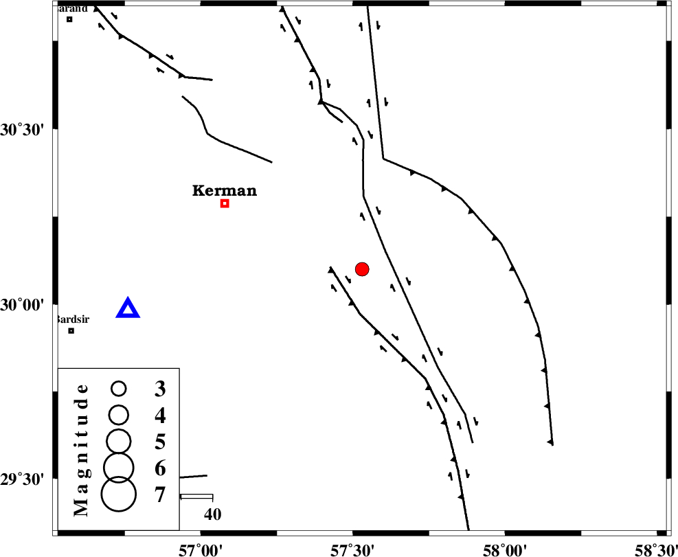
| Location | Lat:30.1 Lon: 57.53 |
| Region | Kerman Province, 48 km South-East of Kerman |
Nearest Cities |
|
| 9 km of Jushan, Kerman Province | |
| 11 km of Sirch, Kerman Province | |
| 24 km North East of Mahan, Kerman Province | |
| 24 km North East of Langar, Kerman Province | |
| 29 km North East of Mohiabad, Kerman Province | |
| Depth | 18 km |
| Agency | |
Faults within 150 km: |
|
| GOLBAF_SIRCH_F (Length: 114 km) , Distance to epicenter: 9 km | |
| GOWK_F (Length: 152 km) , Distance to epicenter: 10 km | |
| NAYBAND_F (Length: 258 km) , Distance to epicenter: 36 km | |
| Number of Phases | 6 |
| RMS | 0.2 |
| Number of Stations | 4 |
| Error in Latitude | >3.3 km |
| Error in Longitude | 4.4 km |
| Error in Depth | 9.9 km |
Download waveform in seisan format
to download seisan software Click here
to access information about IIEES stations Click here
Amplitude | ||||||||
| UID | Agency | Station | Component | Amplitude | Period | Arrival Time | Proccessing Time | Signal Clip |
| 92309 | IIEES | KRBR | N | 435.8 | 0.2 | 2014-04-29 04:58:23 | 2014-04-29 11:50:00 | n |
| 92310 | IIEES | KRBR | E | 511.7 | 0.22 | 2014-04-29 04:58:23 | 2014-04-29 11:50:00 | n |
| 92311 | IIEES | BSRN | N | 46.2 | 0.51 | 2014-04-29 04:59:16 | 2014-04-29 11:50:00 | n |
Phase | ||||||||||||
| Agency | Station | Component | Phase Type | Phase Quality | First Motion | Observed Arrival Time | Time Residual | Loc. Flag | Input Weight | Distance | Azimuth | |
| IIEES | KRBR | Z | Pg | E | 2014-04-29 04:58:12 | -0.18 | y | 74.9 | 261 | |||
| IIEES | KRBR | N | Sg | E | 2014-04-29 04:58:22 | 0.17 | y | 74.9 | 261 | |||
| IIEES | BSRN | Z | Pn | E | 2014-04-29 04:58:38 | 0.03 | y | 258 | 36 | |||
| IIEES | ZHSF | Z | Pn | E | 2014-04-29 04:58:46 | 0.16 | y | 318 | 99 | |||
| IIEES | YZKH | Z | Pn | E | 2014-04-29 04:58:53 | -0.39 | y | 378 | 313 | |||
| IIEES | YZKH | N | Sg | E | 2014-04-29 04:59:45 | 0.2 | y | 378 | 313 | |||