
Magnitude |
2.6 |
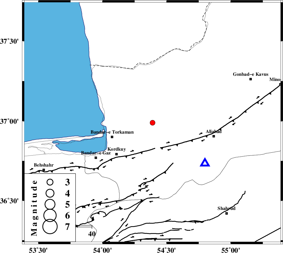
| Date & Time (UTC) | 2014-05-05 23:50:07.0 |
| Date & Time (Local) | 1393/2/16 04:20:07.0 |
| Location | Lat:36.99 Lon: 54.39 |
| Region | Golestan Province, 6 km Aq Qaleh |
Nearest Cities |
|
| 6 km of Aq Qaleh, Golestan Province | |
| 11 km West of Qanqarmeh, Golestan Province | |
| 14 km East of Banavar, Golestan Province | |
| 17 km North of Lamsak, Golestan Province | |
| 18 km North of Gorgan, Golestan Province | |
| Depth | 38 km |
| Agency | |
Faults within 150 km: |
|
| KHAZAR_F (Length: 523 km) , Distance to epicenter: 18 km | |
| N_ALBORZ_F (Length: 360 km) , Distance to epicenter: 42 km | |
| SHAVAR_F (Length: 87 km) , Distance to epicenter: 47 km | |
| Number of Phases | 5 |
| RMS | 0.2 |
| Number of Stations | 3 |
| Error in Latitude | >7 km |
| Error in Longitude | 2.2 km |
| Error in Depth | 8 km |
Download waveform in seisan format
to download seisan software Click here
to access information about IIEES stations Click here
Amplitude | ||||||||
| UID | Agency | Station | Component | Amplitude | Period | Arrival Time | Proccessing Time | Signal Clip |
| 92347 | IIEES | DAMV | E | 30.4 | 0.33 | 2014-05-05 23:51:24 | 2014-05-06 01:36:00 | n |
Phase | ||||||||||||
| Agency | Station | Component | Phase Type | Phase Quality | First Motion | Observed Arrival Time | Time Residual | Loc. Flag | Input Weight | Distance | Azimuth | |
| IIEES | SHRO | Z | Pn | E | 2014-05-05 23:50:34 | -0.27 | y | 182 | 126 | |||
| IIEES | SHRO | E | Sg | E | 2014-05-05 23:50:58 | 0.13 | y | 182 | 126 | |||
| IIEES | DAMV | Z | Pn | E | 2014-05-05 23:50:45 | 0.31 | y | 265 | 236 | |||
| IIEES | DAMV | E | Sg | E | 2014-05-05 23:51:20 | -0.15 | y | 265 | 236 | |||
| IIEES | BJRD | E | Pn | E | 2014-05-05 23:50:47 | -0.01 | y | 279 | 73 | |||