
Magnitude |
2.7 |
| Date & Time (UTC) | 2014-05-12 16:41:17.1 |
| Date & Time (Local) | 1393/2/22 21:11:17.1 |
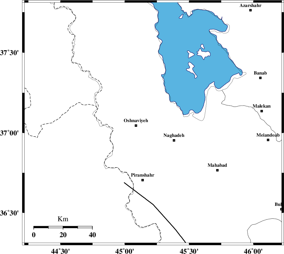
| Location | Lat:37.06 Lon: 45.22 |
| Region | Azarbaijan Gharbi Province, 12 km East of Oshnaviyeh |
Nearest Cities |
|
| 11 km North of Mirabad, Azarbaijan Gharbi Province | |
| 11 km North of Nalus, Azarbaijan Gharbi Province | |
| 12 km North East of Oshnaviyeh, Azarbaijan Gharbi Province | |
| 16 km South East of Aghbelagh, Azarbaijan Gharbi Province | |
| 19 km North West of Naqadeh, Azarbaijan Gharbi Province | |
| Depth | 14 km |
| Agency | |
Faults within 150 km: |
|
| PIRANSHAHR_F (Length: 253 km) , Distance to epicenter: 46 km | |
| SALMAS (Length: 20 km) , Distance to epicenter: 115 km | |
| N_TABRIZ_F2 (Length: 52 km) , Distance to epicenter: 128 km | |
| Number of Phases | 5 |
| RMS | 0.1 |
| Number of Stations | 3 |
| Error in Latitude | >3.8 km |
| Error in Longitude | 7.1 km |
| Error in Depth | 11.2 km |
Download waveform in seisan format
to download seisan software Click here
to access information about IIEES stations Click here
Amplitude | ||||||||
| UID | Agency | Station | Component | Amplitude | Period | Arrival Time | Proccessing Time | Signal Clip |
| 92412 | IIEES | GRMI | N | 26.2 | 0.44 | 2014-05-12 16:42:49 | 2014-05-12 06:15:00 | n |
| 92413 | IIEES | GRMI | E | 25.6 | 0.4 | 2014-05-12 16:42:52 | 2014-05-12 06:15:00 | n |
Phase | ||||||||||||
| Agency | Station | Component | Phase Type | Phase Quality | First Motion | Observed Arrival Time | Time Residual | Loc. Flag | Input Weight | Distance | Azimuth | |
| IIEES | MAKU | Z | Pn | E | 2014-05-12 16:41:57 | -0.06 | y | 260 | 350 | |||
| IIEES | GRMI | Z | Pn | E | 2014-05-12 16:42:02 | 0.24 | y | 305 | 50 | |||
| IIEES | GRMI | N | Sg | E | 2014-05-12 16:42:42 | -0.07 | y | 305 | 50 | |||
| IIEES | ZNJK | Z | Pn | E | 2014-05-12 16:42:03 | -0.12 | y | 312 | 97 | |||
| IIEES | ZNJK | E | Sg | E | 2014-05-12 16:42:44 | 0.02 | y | 312 | 97 | |||