
Magnitude |
2.7 |
| Date & Time (UTC) | 2014-05-24 03:09:00.7 |
| Date & Time (Local) | 1393/3/3 07:39:00.7 |
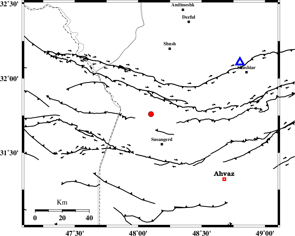
| Location | Lat:31.76 Lon: 48.1 |
| Region | Khoozestan Province, 25 km North of Susangerd |
Nearest Cities |
|
| 12 km North East of Bostan, Khoozestan Province | |
| 24 km North of Susangerd, Khoozestan Province | |
| 28 km West of Abdolkhan-eali, Khoozestan Province | |
| 30 km North West of Jalaliyeh, Khoozestan Province | |
| 33 km North of Hoveizeh, Khoozestan Province | |
| Depth | 18 km |
| Agency | |
Faults within 150 km: |
|
| AHVAZ_F (Length: 99 km) , Distance to epicenter: 12 km | |
| DEZFUL_EMBAYMENT (Length: 228 km) , Distance to epicenter: 88 km | |
| BALARUD_F_Z1 (Length: 87 km) , Distance to epicenter: 110 km | |
| Number of Phases | 6 |
| RMS | 0.2 |
| Number of Stations | 5 |
| Error in Latitude | >2.7 km |
| Error in Longitude | 8.1 km |
| Error in Depth | 6.3 km |
Download waveform in seisan format
to download seisan software Click here
to access information about IIEES stations Click here
Amplitude | ||||||||
| UID | Agency | Station | Component | Amplitude | Period | Arrival Time | Proccessing Time | Signal Clip |
| 92498 | IIEES | KHMZ | E | 37.2 | 0.35 | 2014-05-24 03:10:31 | 2014-05-24 06:20:00 | n |
| 92499 | IIEES | ASAO | E | 14.7 | 0.53 | 2014-05-24 03:10:46 | 2014-05-24 06:20:00 | n |
| 92500 | IIEES | ASAO | N | 16.9 | 0.71 | 2014-05-24 03:10:47 | 2014-05-24 06:20:00 | n |
| 92501 | IIEES | GHVR | E | 12.2 | 0.33 | 2014-05-24 03:10:52 | 2014-05-24 06:20:00 | n |
Phase | ||||||||||||
| Agency | Station | Component | Phase Type | Phase Quality | First Motion | Observed Arrival Time | Time Residual | Loc. Flag | Input Weight | Distance | Azimuth | |
| IIEES | KHMZ | Z | Pg | E | 2014-05-24 03:09:46 | -0.1 | y | 281 | 38 | |||
| IIEES | ASAO | Z | Pn | E | 2014-05-24 03:09:52 | -0.13 | y | 357 | 30 | |||
| IIEES | SNGE | Z | Pn | E | 2014-05-24 03:09:55 | 0.14 | y | 376 | 350 | |||
| IIEES | GHVR | Z | Pn | E | 2014-05-24 03:10:00 | 0.21 | y | 421 | 43 | |||
| IIEES | AHRM | Z | Pn | E | 2014-05-24 03:10:02 | -0.23 | y | 445 | 135 | |||
| IIEES | AHRM | E | Sg | E | 2014-05-24 03:11:04 | 0.14 | y | 445 | 135 | |||