
Magnitude |
2.9 |
| Date & Time (UTC) | 2014-06-05 17:04:53.6 |
| Date & Time (Local) | 1393/3/15 21:34:53.6 |
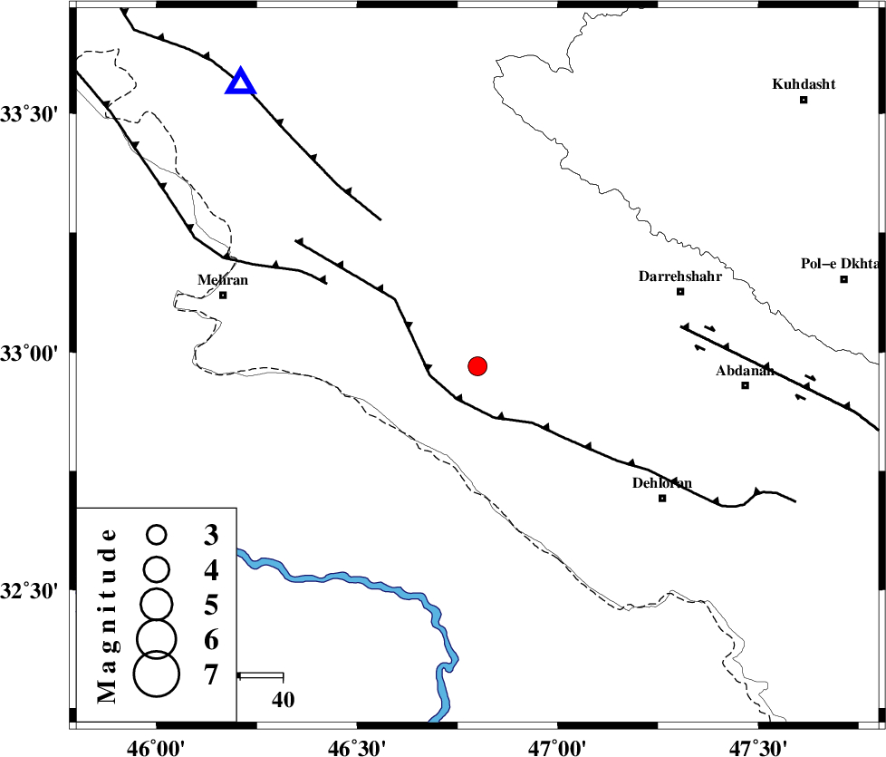
| Location | Lat:32.97 Lon: 46.8 |
| Region | Ilam Province, 50 km South-West of Darreh Shahr |
Nearest Cities |
|
| 23 km North West of Bishehzar, Ilam Province | |
| 32 km South West of Meymeh, Ilam Province | |
| 37 km South West of Badreh, Ilam Province | |
| 38 km South East of Gonbad-e pirmohammad, Ilam Province | |
| 50 km South West of Darreh Shahr, Ilam Province | |
| Depth | 18 km |
| Agency | |
Faults within 150 km: |
|
| MFF6 (Length: 144 km) , Distance to epicenter: 9 km | |
| ZFF4 (Length: 128 km) , Distance to epicenter: 40 km | |
| MFF7 (Length: 99 km) , Distance to epicenter: 41 km | |
| Number of Phases | 5 |
| RMS | 0 |
| Number of Stations | 4 |
| Error in Latitude | >4.2 km |
| Error in Longitude | 9.5 km |
| Error in Depth | 6 km |
Download waveform in seisan format
to download seisan software Click here
to access information about IIEES stations Click here
Amplitude | ||||||||
| UID | Agency | Station | Component | Amplitude | Period | Arrival Time | Proccessing Time | Signal Clip |
| 92557 | IIEES | SHGR | N | 94.3 | 0.36 | 2014-06-05 17:06:03 | 2014-06-05 06:44:00 | n |
Phase | ||||||||||||
| Agency | Station | Component | Phase Type | Phase Quality | First Motion | Observed Arrival Time | Time Residual | Loc. Flag | Input Weight | Distance | Azimuth | |
| IIEES | SHGR | N | Sg | E | 2014-06-05 17:05:53 | 0 | y | 211 | 117 | |||
| IIEES | SNGE | Z | P | E | 2014-06-05 17:05:30 | 0.01 | y | 240 | 12 | |||
| IIEES | SNGE | N | Sg | E | 2014-06-05 17:06:01 | 0 | y | 240 | 12 | |||
| IIEES | KHMZ | Z | P | E | 2014-06-05 17:05:39 | 0.07 | y | 306 | 73 | |||
| IIEES | ASAO | Z | P | E | 2014-06-05 17:05:44 | -0.08 | y | 346 | 59 | |||