
Magnitude |
4.5 |
| Date & Time (UTC) | 2014-06-12 02:37:18.9 |
| Date & Time (Local) | 1393/3/22 07:07:18.9 |
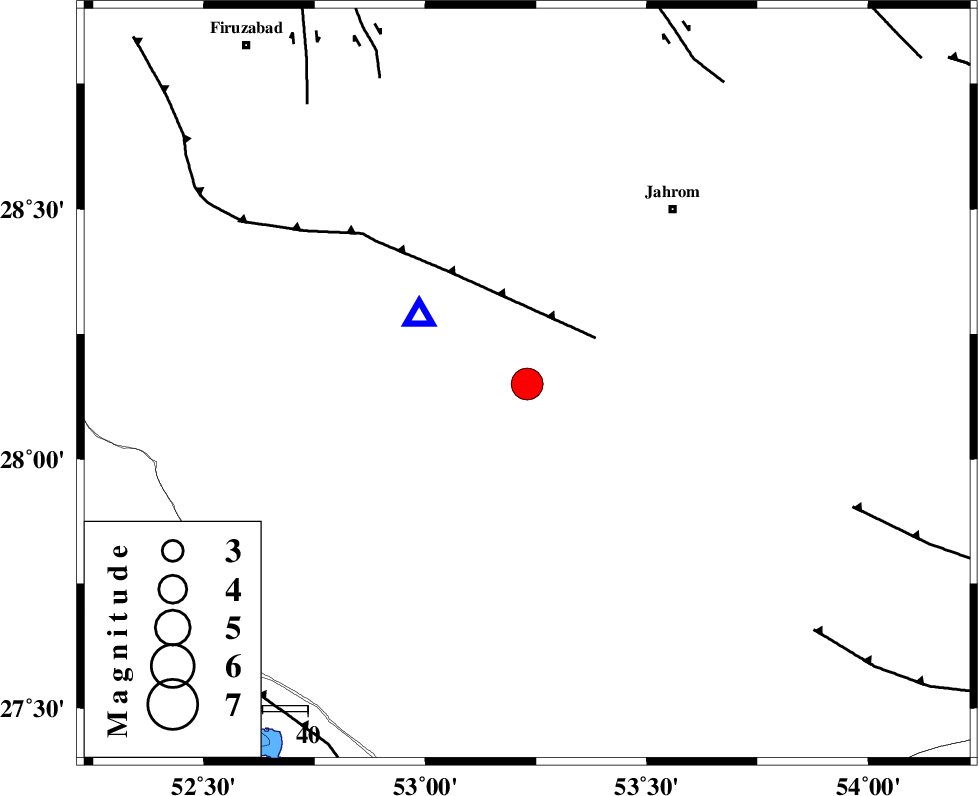
| Location | Lat:28.15 Lon: 53.23 |
| Region | Fars Province, 40 km South-East of Qir va Karzin |
Nearest Cities |
|
| 8 km of Seyfabad, Fars Province | |
| 26 km South of Mobarakabad, Fars Province | |
| 33 km South East of Shahrak-e jonubi, Fars Province | |
| 36 km West of Balafan, Fars Province | |
| 36 km North West of Khonj, Fars Province | |
| Depth | 17 km |
| Agency | |
Faults within 150 km: |
|
| QIR_F (Length: 130 km) , Distance to epicenter: 18 km | |
| SABZ_PUSHAN_F_Z2 (Length: 24 km) , Distance to epicenter: 75 km | |
| BERIZ_F (Length: 49 km) , Distance to epicenter: 77 km | |
| Number of Phases | 8 |
| RMS | 0 |
| Number of Stations | 5 |
| Error in Latitude | >4.6 km |
| Error in Longitude | 1.3 km |
| Error in Depth | 4.7 km |
Download waveform in seisan format
to download seisan software Click here
to access information about IIEES stations Click here
Amplitude | ||||||||
| UID | Agency | Station | Component | Amplitude | Period | Arrival Time | Proccessing Time | Signal Clip |
| 92585 | IIEES | KHMZ | E | 124.9 | 0.52 | 2014-06-12 02:40:06 | 2014-06-12 04:17:00 | n |
Phase | ||||||||||||
| Agency | Station | Component | Phase Type | Phase Quality | First Motion | Observed Arrival Time | Time Residual | Loc. Flag | Input Weight | Distance | Azimuth | |
| IIEES | AHRM | Z | Pn | E | 2014-06-12 02:37:51 | 0.07 | y | 205 | 293 | |||
| IIEES | AHRM | N | Sg | E | 2014-06-12 02:38:16 | -0.03 | y | 205 | 293 | |||
| IIEES | KRBR | Z | Pn | E | 2014-06-12 02:38:16 | -0.07 | y | 400 | 59 | |||
| IIEES | KHMZ | Z | Pn | E | 2014-06-12 02:38:52 | -0.04 | y | 694 | 334 | |||
| IIEES | BSRN | Z | Pn | E | 2014-06-12 02:38:54 | -0.01 | y | 709 | 52 | |||
| IIEES | BSRN | E | Sg | E | 2014-06-12 02:40:35 | 0.07 | y | 709 | 52 | |||
| IIEES | TABS | Z | Pn | E | 2014-06-12 02:38:55 | 0.02 | y | 715 | 30 | |||
| IIEES | TABS | E | Sg | E | 2014-06-12 02:40:37 | -0.01 | y | 715 | 30 | |||