
Magnitude |
3.1 |
| Date & Time (UTC) | 2014-06-24 19:14:08.8 |
| Date & Time (Local) | 1393/4/3 23:44:08.8 |
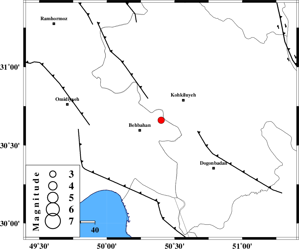
| Location | Lat:30.66 Lon: 50.4 |
| Region | Khoozestan Province, 17 km East of Behbahan |
Nearest Cities |
|
| 10 km North East of Mansuriyeh, Khoozestan Province | |
| 17 km North East of Behbahan, Khoozestan Province | |
| 21 km South West of Dehdasht, Kohkiluieh va boyerahmad Province | |
| 22 km East of Dodange-ye bozorg, Khoozestan Province | |
| 36 km South of Lendeh, Kohkiluieh va boyerahmad Province | |
| Depth | 14 km |
| Agency | |
Faults within 150 km: |
|
| MFF4 (Length: 62 km) , Distance to epicenter: 18 km | |
| MISHAN_F (Length: 76 km) , Distance to epicenter: 27 km | |
| AGHAJARI_F (Length: 88 km) , Distance to epicenter: 51 km | |
| Number of Phases | 5 |
| RMS | 0.2 |
| Number of Stations | 3 |
| Error in Latitude | >8 km |
| Error in Longitude | 10.7 km |
| Error in Depth | 11.9 km |
Download waveform in seisan format
to download seisan software Click here
to access information about IIEES stations Click here
Amplitude | ||||||||
| UID | Agency | Station | Component | Amplitude | Period | Arrival Time | Proccessing Time | Signal Clip |
| 92665 | IIEES | SHGR | N | 174.3 | 0.36 | 2014-06-24 19:15:27 | 2014-06-24 08:44:00 | n |
| 92666 | IIEES | SHGR | E | 155.4 | 0.36 | 2014-06-24 19:15:31 | 2014-06-24 08:44:00 | n |
Phase | ||||||||||||
| Agency | Station | Component | Phase Type | Phase Quality | First Motion | Observed Arrival Time | Time Residual | Loc. Flag | Input Weight | Distance | Azimuth | |
| IIEES | SHGR | Z | Pg | E | 2014-06-24 19:14:44 | -0.09 | y | 221 | 317 | |||
| IIEES | KHMZ | Z | Pn | E | 2014-06-24 19:14:59 | -0.1 | y | 344 | 353 | |||
| IIEES | KHMZ | E | Sg | E | 2014-06-24 19:15:45 | 0.22 | y | 344 | 353 | |||
| IIEES | GHVR | Z | Pn | E | 2014-06-24 19:15:10 | 0.26 | y | 431 | 10 | |||
| IIEES | GHVR | N | Sg | E | 2014-06-24 19:16:08 | -0.26 | y | 431 | 10 | |||