
Magnitude |
2.9 |
| Date & Time (UTC) | 2014-08-05 22:10:04.8 |
| Date & Time (Local) | 1393/5/15 02:40:04.8 |
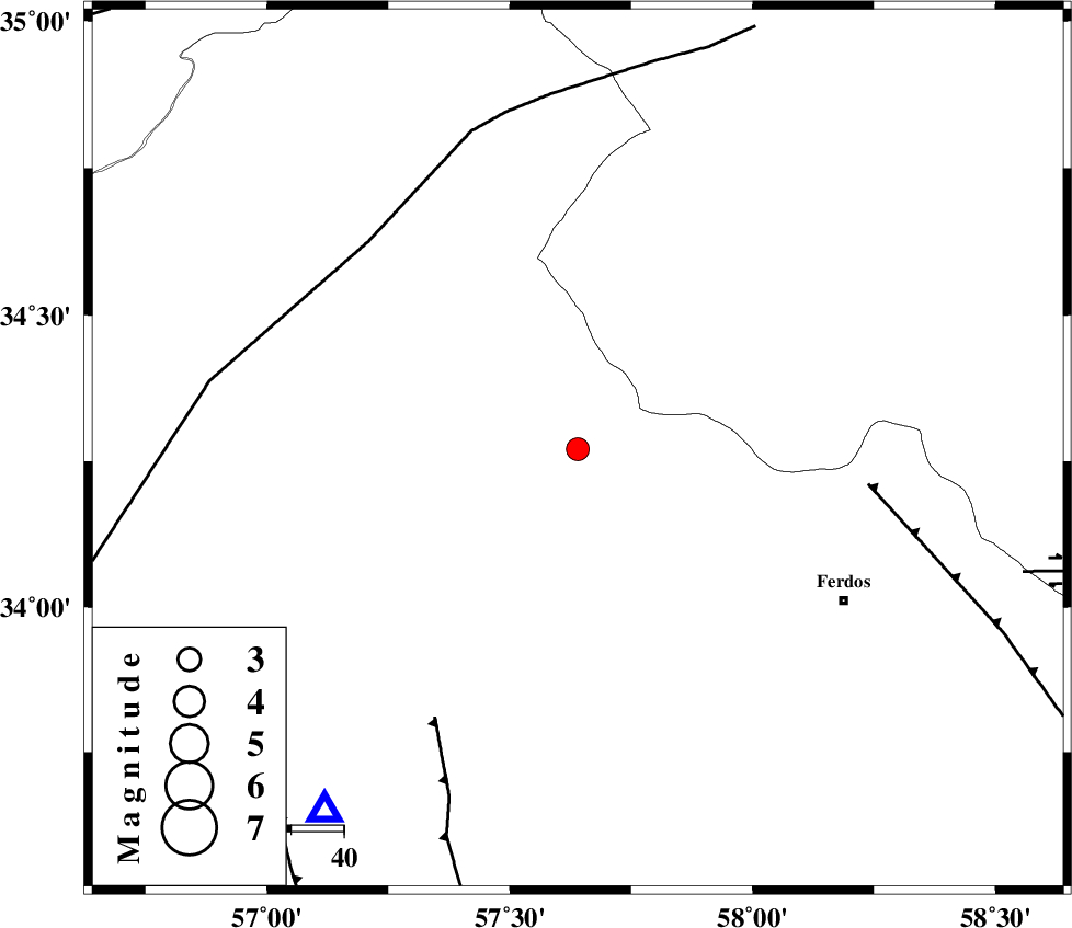
| Location | Lat:34.27 Lon: 57.64 |
| Region | Khorasan(center) Province, 58 km North-West of Ferdows |
Nearest Cities |
|
| 37 km North East of Qaniabad, Khorasan(center) Province | |
| 49 km North East of Boshravieh, Khorasan(center) Province | |
| 51 km North West of Khankuk, Khorasan(center) Province | |
| 51 km South West of Mazar, Khorasan(center) Province | |
| 55 km South West of Zinabad, Khorasan(center) Province | |
| Depth | 30 km |
| Agency | |
Faults within 150 km: |
|
| FERDOWS_F (Length: 101 km) , Distance to epicenter: 55 km | |
| NAINI_F (Length: 342 km) , Distance to epicenter: 56 km | |
| ESFARDIAR_F (Length: 94 km) , Distance to epicenter: 58 km | |
| Number of Phases | 5 |
| RMS | 0.2 |
| Number of Stations | 3 |
| Error in Latitude | >11.7 km |
| Error in Longitude | 3.4 km |
| Error in Depth | 8.5 km |
Download waveform in seisan format
to download seisan software Click here
to access information about IIEES stations Click here
Amplitude | ||||||||
| UID | Agency | Station | Component | Amplitude | Period | Arrival Time | Proccessing Time | Signal Clip |
| 92907 | IIEES | YZKH | N | 29.5 | 0.4 | 2014-08-05 22:11:54 | 2014-08-06 12:14:00 | n |
Phase | ||||||||||||
| Agency | Station | Component | Phase Type | Phase Quality | First Motion | Observed Arrival Time | Time Residual | Loc. Flag | Input Weight | Distance | Azimuth | |
| IIEES | TABS | Z | Pg | E | 2014-08-05 22:10:19 | -0.07 | y | 84.6 | 215 | |||
| IIEES | TABS | N | Sg | E | 2014-08-05 22:10:30 | -0.04 | y | 84.6 | 215 | |||
| IIEES | SHRT | Z | Pn | E | 2014-08-05 22:10:42 | -0.22 | y | 254 | 105 | |||
| IIEES | SHRT | E | Sg | E | 2014-08-05 22:11:15 | 0.14 | y | 254 | 105 | |||
| IIEES | YZKH | Z | Pn | E | 2014-08-05 22:10:55 | 0.23 | y | 353 | 235 | |||