
Magnitude |
3.4 |
| Date & Time (UTC) | 2014-08-31 04:54:54.8 |
| Date & Time (Local) | 1393/6/9 09:24:54.8 |
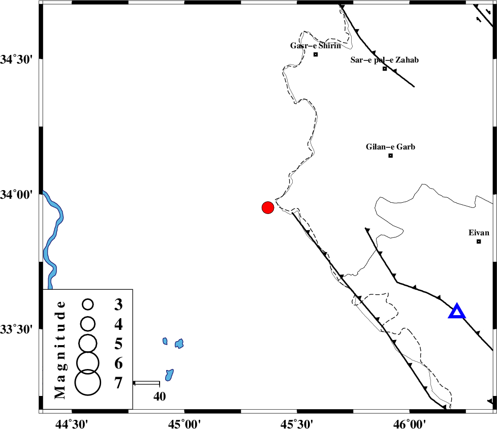
| Location | Lat:33.95 Lon: 45.37 |
| Region | Iraq, 55 km South-West of Gilan-E-Gharb |
Nearest Cities |
|
| 26 km North West of Sumar, Kermanshah Province | |
| 51 km South West of Khosravi, Kermanshah Province | |
| 55 km South West of Gilan-E-Gharb, Kermanshah Province | |
| 55 km West of Nian, Kermanshah Province | |
| 59 km South West of Seyyed sohrab, Kermanshah Province | |
| Depth | 14 km |
| Agency | |
Faults within 150 km: |
|
| ZFF4 (Length: 128 km) , Distance to epicenter: 10 km | |
| MFF7 (Length: 99 km) , Distance to epicenter: 41 km | |
| MFF8 (Length: 48 km) , Distance to epicenter: 76 km | |
| Number of Phases | 6 |
| RMS | 0.2 |
| Number of Stations | 4 |
| Error in Latitude | >8.3 km |
| Error in Longitude | 7 km |
| Error in Depth | 7.4 km |
Download waveform in seisan format
to download seisan software Click here
to access information about IIEES stations Click here
Amplitude | ||||||||
| UID | Agency | Station | Component | Amplitude | Period | Arrival Time | Proccessing Time | Signal Clip |
| 93404 | IIEES | SNGE | N | 284.5 | 0.36 | 2014-08-31 04:56:02 | 2014-08-31 06:17:00 | n |
Phase | ||||||||||||
| Agency | Station | Component | Phase Type | Phase Quality | First Motion | Observed Arrival Time | Time Residual | Loc. Flag | Input Weight | Distance | Azimuth | |
| IIEES | SNGE | Z | Pn | E | 2014-08-31 04:55:30 | 0.04 | y | 222 | 55 | |||
| IIEES | SNGE | N | Sg | E | 2014-08-31 04:55:57 | -0.06 | y | 222 | 55 | |||
| IIEES | KHMZ | Z | Pn | E | 2014-08-31 04:55:55 | -0.31 | y | 426 | 92 | |||
| IIEES | ASAO | Z | Pn | E | 2014-08-31 04:55:57 | 0.31 | y | 434 | 80 | |||
| IIEES | ASAO | N | S | E | 2014-08-31 04:56:41 | 0.1 | y | 434 | 80 | |||
| IIEES | CHTH | Z | Pn | E | 2014-08-31 04:56:13 | -0.09 | y | 569 | 66 | |||