
Magnitude |
2.8 |
| Date & Time (UTC) | 2014-09-01 01:57:29.6 |
| Date & Time (Local) | 1393/6/10 06:27:29.6 |
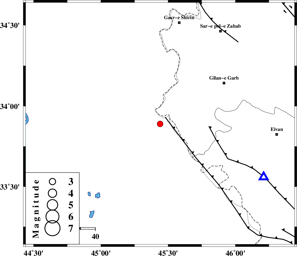
| Location | Lat:33.89 Lon: 45.44 |
| Region | Iraq, 52 km South-West of Gilan-E-Gharb |
Nearest Cities |
|
| 19 km North West of Sumar, Kermanshah Province | |
| 50 km South West of Nian, Kermanshah Province | |
| 52 km South West of Gilan-E-Gharb, Kermanshah Province | |
| 57 km South of Khosravi, Kermanshah Province | |
| 61 km South West of Chub baghan, Kermanshah Province | |
| Depth | 14 km |
| Agency | |
Faults within 150 km: |
|
| ZFF4 (Length: 128 km) , Distance to epicenter: 6 km | |
| MFF7 (Length: 99 km) , Distance to epicenter: 34 km | |
| MFF8 (Length: 48 km) , Distance to epicenter: 78 km | |
| Number of Phases | 5 |
| RMS | 0 |
| Number of Stations | 3 |
| Error in Latitude | >4.9 km |
| Error in Longitude | 4.6 km |
| Error in Depth | 4.6 km |
Download waveform in seisan format
to download seisan software Click here
to access information about IIEES stations Click here
Amplitude | ||||||||
| UID | Agency | Station | Component | Amplitude | Period | Arrival Time | Proccessing Time | Signal Clip |
| 93433 | IIEES | SNGE | N | 77 | 0.57 | 2014-09-01 01:58:34 | 2014-09-01 03:30:00 | n |
Phase | ||||||||||||
| Agency | Station | Component | Phase Type | Phase Quality | First Motion | Observed Arrival Time | Time Residual | Loc. Flag | Input Weight | Distance | Azimuth | |
| IIEES | SNGE | Z | Pn | E | 2014-09-01 01:58:04 | 0 | y | 221 | 52 | |||
| IIEES | SNGE | N | Sg | E | 2014-09-01 01:58:32 | 0 | y | 221 | 52 | |||
| IIEES | KHMZ | Z | Pn | E | 2014-09-01 01:58:29 | 0.02 | y | 419 | 91 | |||
| IIEES | ASAO | Z | Pn | E | 2014-09-01 01:58:30 | -0.02 | y | 429 | 79 | |||
| IIEES | ASAO | N | Sn | 2014-09-01 01:59:15 | 0 | y | 429 | 79 | ||||