
Magnitude |
3.2 |
| Date & Time (UTC) | 2014-09-05 07:48:27.5 |
| Date & Time (Local) | 1393/6/14 12:18:27.5 |
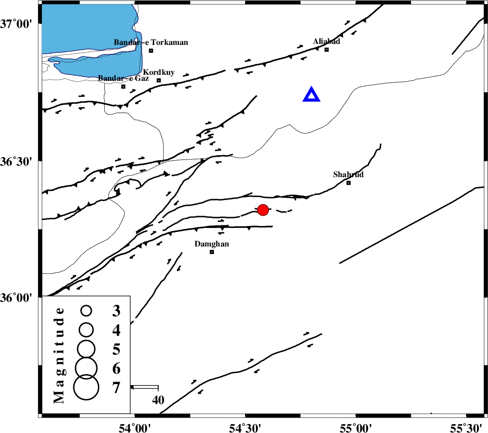
| Location | Lat:36.32 Lon: 54.58 |
| Region | Semnan Province, 27 km North-East of Damghan |
Nearest Cities |
|
| 12 km North of Mehmandust, Semnan Province | |
| 18 km South of Majen, Semnan Province | |
| 27 km North East of Damghan, Semnan Province | |
| 28 km South East of Cheharbagh, Golestan Province | |
| 36 km West of Shahrud, Semnan Province | |
| Depth | 14 km |
| Agency | |
Faults within 150 km: |
|
| DAMGHAN_F (Length: 95 km) , Distance to epicenter: 8 km | |
| ATARI_F (Length: 185 km) , Distance to epicenter: 9 km | |
| ASTANEH_F (Length: 72 km) , Distance to epicenter: 18 km | |
| Number of Phases | 8 |
| RMS | 0.3 |
| Number of Stations | 7 |
| Error in Latitude | >9.3 km |
| Error in Longitude | 2.3 km |
| Error in Depth | 6.1 km |
Download waveform in seisan format
to download seisan software Click here
to access information about IIEES stations Click here
Amplitude | ||||||||
| UID | Agency | Station | Component | Amplitude | Period | Arrival Time | Proccessing Time | Signal Clip |
| 93506 | IIEES | THKV | N | 70.8 | 0.51 | 2014-09-05 07:49:41 | 2014-09-06 10:17:00 | n |
Phase | ||||||||||||
| Agency | Station | Component | Phase Type | Phase Quality | First Motion | Observed Arrival Time | Time Residual | Loc. Flag | Input Weight | Distance | Azimuth | |
| IIEES | SHRO | E | Pg | E | 2014-09-05 07:48:49 | -0.34 | y | 133 | 105 | |||
| IIEES | DAMV | Z | Pn | E | 2014-09-05 07:49:06 | 0.3 | y | 248 | 253 | |||
| IIEES | DAMV | E | Sg | E | 2014-09-05 07:49:37 | -0.11 | y | 248 | 253 | |||
| IIEES | CHTH | Z | Pn | E | 2014-09-05 07:49:14 | 0.38 | y | 315 | 263 | |||
| IIEES | CHTH | E | Sg | E | 2014-09-05 07:49:55 | -0.37 | y | 315 | 263 | |||
| IIEES | TABS | Z | Pn | E | 2014-09-05 07:49:22 | 0.29 | y | 376 | 141 | |||
| IIEES | ZNJK | Z | Pn | E | 2014-09-05 07:49:41 | -0.01 | y | 530 | 276 | |||
| IIEES | SHRT | Z | Pn | E | 2014-09-05 07:49:49 | -0.15 | y | 600 | 118 | |||