
Magnitude |
3.4 |
| Date & Time (UTC) | 2014-09-12 02:09:08.5 |
| Date & Time (Local) | 1393/6/21 06:39:08.5 |
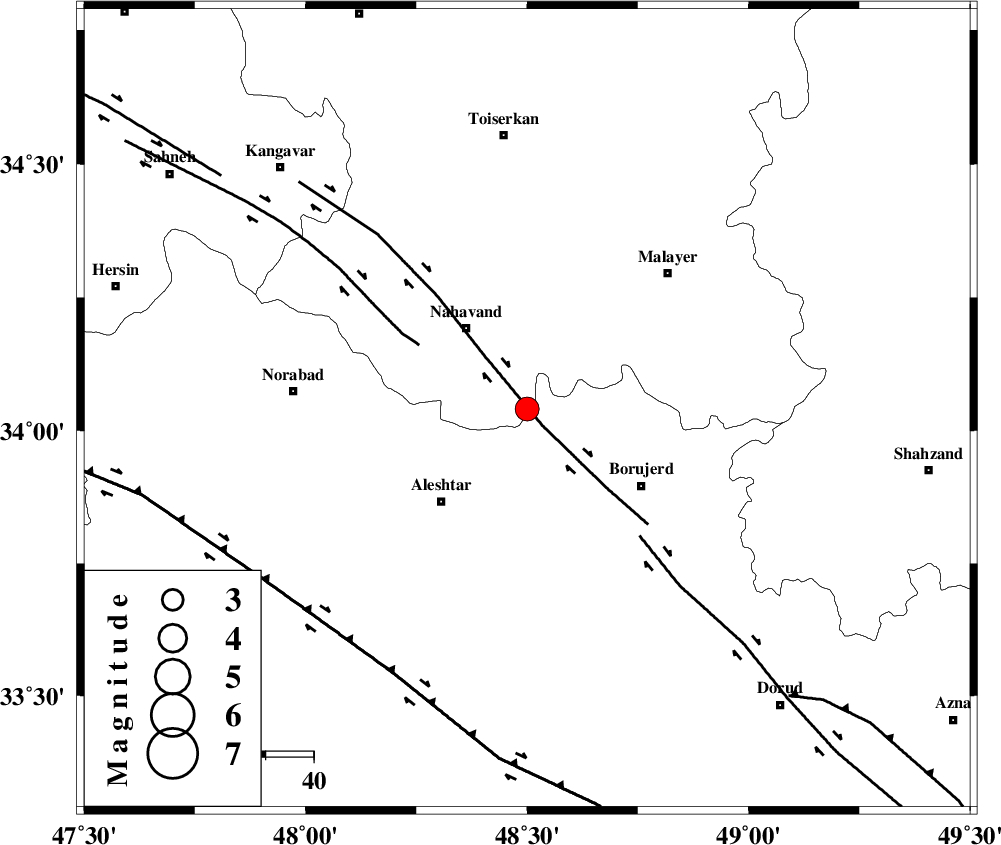
| Location | Lat:34.04 Lon: 48.5 |
| Region | Hamedan Province, 21 km South-East of Nahavand |
Nearest Cities |
|
| 5 km of Babaqasem, Hamedan Province | |
| 5 km of Jaefarabad, Lorestan Province | |
| 11 km of Anuj, Hamedan Province | |
| 14 km North West of Ashtarinan, Lorestan Province | |
| 17 km North West of Bon dizeh, Lorestan Province | |
| Depth | 14 km |
| Agency | |
Faults within 150 km: |
|
| NAHAVAND_F (Length: 102 km) , Distance to epicenter: 5 km | |
| SAHANEH_F (Length: 77 km) , Distance to epicenter: 26 km | |
| DORUD (Length: 100 km) , Distance to epicenter: 35 km | |
| Number of Phases | 6 |
| RMS | 0.1 |
| Number of Stations | 5 |
| Error in Latitude | >2.1 km |
| Error in Longitude | 1.1 km |
| Error in Depth | 4.4 km |
Download waveform in seisan format
to download seisan software Click here
to access information about IIEES stations Click here
Amplitude | ||||||||
| UID | Agency | Station | Component | Amplitude | Period | Arrival Time | Proccessing Time | Signal Clip |
| 93570 | IIEES | ASAO | N | 642.9 | 0.4 | 2014-09-12 02:09:56 | 2014-09-14 07:54:00 | n |
| 93571 | IIEES | ASAO | E | 562.7 | 0.44 | 2014-09-12 02:09:57 | 2014-09-14 07:54:00 | n |
| 93572 | IIEES | GHVR | E | 190.9 | 0.48 | 2014-09-12 02:10:27 | 2014-09-14 07:54:00 | n |
Phase | ||||||||||||
| Agency | Station | Component | Phase Type | Phase Quality | First Motion | Observed Arrival Time | Time Residual | Loc. Flag | Input Weight | Distance | Azimuth | |
| IIEES | ASAO | Z | Pg | E | 2014-09-12 02:09:33 | 0.07 | y | 152 | 68 | |||
| IIEES | ASAO | N | Sg | E | 2014-09-12 02:09:52 | -0.07 | y | 152 | 68 | |||
| IIEES | SNGE | Z | Pg | E | 2014-09-12 02:09:34 | 0.05 | y | 157 | 318 | |||
| IIEES | SNGE | N | Sg | E | 2014-09-12 02:09:53 | -0.05 | y | 157 | 318 | |||
| IIEES | SHGR | Z | Pn | E | 2014-09-12 02:09:42 | -0.04 | y | 216 | 172 | |||
| IIEES | DAMV | Z | Pn | E | 2014-09-12 02:10:01 | 0.05 | y | 363 | 60 | |||