
Magnitude |
2.8 |
| Date & Time (UTC) | 2014-10-03 15:51:54.1 |
| Date & Time (Local) | 1393/7/11 19:21:54.1 |
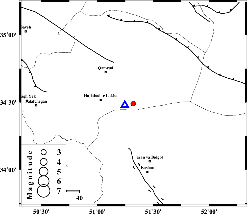
| Location | Lat:34.49 Lon: 51.32 |
| Region | Qom Province, 50 km North-West of Aran va bidgol |
Nearest Cities |
|
| 27 km East of Hajiabad-e lakha, Qom Province | |
| 34 km South East of Qamrud, Qom Province | |
| 36 km North of Mashgan, Esfahan Province | |
| 40 km North East of Yahyaabad, Esfahan Province | |
| 40 km North of Nasrabad, Esfahan Province | |
| Depth | 6 km |
| Agency | |
Faults within 150 km: |
|
| KASHAN_F (Length: 44 km) , Distance to epicenter: 37 km | |
| KUSHK_E_NOSRAT_F (Length: 230 km) , Distance to epicenter: 37 km | |
| SIAHKUH_F (Length: 154 km) , Distance to epicenter: 64 km | |
| Number of Phases | 5 |
| RMS | 0.1 |
| Number of Stations | 5 |
| Error in Latitude | >3.1 km |
| Error in Longitude | 4.2 km |
| Error in Depth | 4.2 km |
Download waveform in seisan format
to download seisan software Click here
to access information about IIEES stations Click here
Amplitude | ||||||||
| UID | Agency | Station | Component | Amplitude | Period | Arrival Time | Proccessing Time | Signal Clip |
| 93738 | IIEES | GHVR | N | 22248.3 | 0.08 | 2014-10-03 15:51:57 | 2014-10-03 04:08:00 | n |
| 93739 | IIEES | GHVR | E | 32417.9 | 0.16 | 2014-10-03 15:51:57 | 2014-10-03 04:08:00 | n |
| 93740 | IIEES | KHMZ | E | 47.9 | 0.4 | 2014-10-03 15:52:44 | 2014-10-03 04:08:00 | n |
| 93741 | IIEES | CHTH | E | 32.4 | 0.52 | 2014-10-03 15:52:48 | 2014-10-03 04:08:00 | n |
Phase | ||||||||||||
| Agency | Station | Component | Phase Type | Phase Quality | First Motion | Observed Arrival Time | Time Residual | Loc. Flag | Input Weight | Distance | Azimuth | |
| IIEES | GHVR | Z | Pg | E | 2014-10-03 15:51:55 | -0.12 | y | 7.33 | 261 | |||
| IIEES | ASAO | Z | Pg | E | 2014-10-03 15:52:15 | 0.12 | y | 119 | 273 | |||
| IIEES | DAMV | Z | Pg | E | 2014-10-03 15:52:18 | 0.06 | y | 140 | 25 | |||
| IIEES | KHMZ | Z | Pg | E | 2014-10-03 15:52:20 | 0.01 | y | 151 | 237 | |||
| IIEES | CHTH | Z | Pg | E | 2014-10-03 15:52:21 | -0.07 | y | 158 | 354 | |||