
Magnitude |
4 |
| Date & Time (UTC) | 2014-10-03 20:39:55.9 |
| Date & Time (Local) | 1393/7/12 00:09:55.9 |
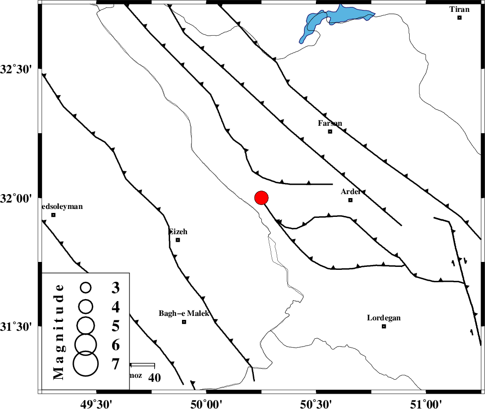
| Location | Lat:32 Lon: 50.25 |
| Region | Chaharmahal Bakhtiari Province, 38 km West of Ardel |
Nearest Cities |
|
| 28 km North of Dehdez, Khoozestan Province | |
| 29 km West of Rostamabad, Chaharmahal Bakhtiari Province | |
| 35 km North West of Dupelan, Chaharmahal Bakhtiari Province | |
| 38 km North West of Ardel, Chaharmahal Bakhtiari Province | |
| 40 km North West of Sarkhun, Chaharmahal Bakhtiari Province | |
| Depth | 14 km |
| Agency | |
Faults within 150 km: |
|
| DOPOLAN_F (Length: 107 km) , Distance to epicenter: 1 km | |
| ZARDKUH_F (Length: 139 km) , Distance to epicenter: 9 km | |
| SABZKUH_F (Length: 67 km) , Distance to epicenter: 11 km | |
| Number of Phases | 7 |
| RMS | 0.3 |
| Number of Stations | 7 |
| Error in Latitude | >3.5 km |
| Error in Longitude | 8.2 km |
| Error in Depth | 9.2 km |
Download waveform in seisan format
to download seisan software Click here
to access information about IIEES stations Click here
Amplitude | ||||||||
| UID | Agency | Station | Component | Amplitude | Period | Arrival Time | Proccessing Time | Signal Clip |
| 93746 | IIEES | BNDS | N | 27.7 | 0.4 | 2014-10-03 20:43:11 | 2014-10-03 09:44:00 | n |
Phase | ||||||||||||
| Agency | Station | Component | Phase Type | Phase Quality | First Motion | Observed Arrival Time | Time Residual | Loc. Flag | Input Weight | Distance | Azimuth | |
| IIEES | KHMZ | Z | Pg | E | 2014-10-03 20:40:27 | -0.36 | y | 195 | 352 | |||
| IIEES | KHMZ | E | Sg | E | 2014-10-03 20:40:51 | 0.05 | y | 195 | 352 | |||
| IIEES | ASAO | Z | Pn | E | 2014-10-03 20:40:39 | 0.15 | y | 284 | 356 | |||
| IIEES | GHVR | Z | Pn | E | 2014-10-03 20:40:40 | 0.44 | y | 290 | 18 | |||
| IIEES | AHRM | Z | P | E | 2014-10-03 20:40:48 | -0.01 | y | 362 | 164 | |||
| IIEES | YZKH | Z | Pn | E | 2014-10-03 20:40:54 | -0.06 | y | 412 | 83 | |||
| IIEES | TABS | Z | Pn | E | 2014-10-03 20:41:26 | -0.38 | y | 669 | 72 | |||