
Magnitude |
1.9 |
| Date & Time (UTC) | 2014-10-10 21:35:16.4 |
| Date & Time (Local) | 1393/7/19 01:05:16.4 |
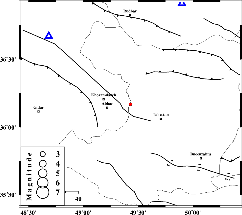
| Location | Lat:36.17 Lon: 49.43 |
| Region | Ghazvin Province, 19 km East of Abhar |
Nearest Cities |
|
| 15 km North of Farsejin, Ghazvin Province | |
| 15 km North East of Sharifabad, Zanjan Province | |
| 18 km South West of Nikuyeh, Ghazvin Province | |
| 19 km North East of Abhar, Zanjan Province | |
| 20 km North of Ziaabad, Ghazvin Province | |
| Depth | 41 km |
| Agency | |
Faults within 150 km: |
|
| ZANJAN_F (Length: 137 km) , Distance to epicenter: 7 km | |
| N_QAZVIN_F (Length: 72 km) , Distance to epicenter: 28 km | |
| SOLTANIYEH_F (Length: 119 km) , Distance to epicenter: 30 km | |
| Number of Phases | 6 |
| RMS | 0.3 |
| Number of Stations | 3 |
| Error in Latitude | >46.6 km |
| Error in Longitude | 24.6 km |
| Error in Depth | 11 km |
Download waveform in seisan format
to download seisan software Click here
to access information about IIEES stations Click here
Amplitude | ||||||||
| UID | Agency | Station | Component | Amplitude | Period | Arrival Time | Proccessing Time | Signal Clip |
| 93835 | IIEES | ZNJK | E | 37.1 | 0.07 | 2014-10-10 21:35:44 | 2014-10-10 10:27:00 | n |
| 93836 | IIEES | CHTH | N | 17.9 | 0.2 | 2014-10-10 21:36:01 | 2014-10-10 10:27:00 | n |
Phase | ||||||||||||
| Agency | Station | Component | Phase Type | Phase Quality | First Motion | Observed Arrival Time | Time Residual | Loc. Flag | Input Weight | Distance | Azimuth | |
| IIEES | ZNJK | Z | Pg | E | 2014-10-10 21:35:32 | 0.05 | y | 86.8 | 310 | |||
| IIEES | ZNJK | E | Sg | E | 2014-10-10 21:35:43 | -0.04 | y | 86.8 | 310 | |||
| IIEES | THKV | Z | Pn | E | 2014-10-10 21:35:37 | -0.56 | y | 133 | 102 | |||
| IIEES | THKV | N | Sg | E | 2014-10-10 21:35:55 | 0.08 | y | 133 | 102 | |||
| IIEES | CHTH | Z | Pn | E | 2014-10-10 21:35:41 | 0.55 | y | 155 | 100 | |||
| IIEES | CHTH | N | Sg | E | 2014-10-10 21:36:01 | -0.08 | y | 155 | 100 | |||